IMAGES TAKEN NEAR TO
Winterburn, SKIPTON, BD23 3QP
Introduction
This page details the photographs taken nearby to BD23 3QP by members of the Geograph project.
The Geograph project started in 2005 with the aim of publishing, organising and preserving representative images for every square kilometre of Great Britain, Ireland and the Isle of Man.

There are currently over 7.5m images from over14,400 individuals and you can help contribute to the project by visiting https://www.geograph.org.uk
Image Map
Images are licensed for reuse under creativecommons.org/licenses/by-sa/2.0
Notes
- Clicking on the map will re-center to the selected point.
- The higher the marker number, the further away the image location is from the centre of the postcode.
Image Listing (11 Images Found)
Images are licensed for reuse under creativecommons.org/licenses/by-sa/2.0
Image
Details
Distance
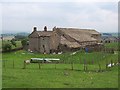
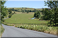
1
Cowper Cote
See Image for a view from the other side. The farmhouse is listed grade II (list entry 1317080).
Image: © Stephen Craven
Taken: 8 May 2018
0.01 miles
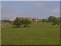
3
Cowper Cote
Farm between Airton and Winterburn
Image: © Chris Heaton
Taken: 28 Jun 2006
0.10 miles
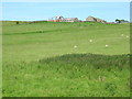
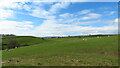
4
Yorkshire Dales National Park
Looking across to Friar's Head from Abbey Hill, Scarnber Hill in the distance.
Image: © Kate Jewell
Taken: 17 Jul 2006
0.12 miles
5
Abbey Hill, near Winterburn
This stream flows out of Winterburn Reservoir in Image and turns into Eshton Beck just down stream of Friar's Head in Image
Image: © Kate Jewell
Taken: 17 Jul 2006
0.12 miles
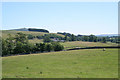
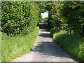
6
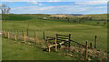
Field path W of Cowper Cote leading towards Farlands Laithe
Image: © Colin Park
Taken: 27 Mar 2022
0.13 miles
7
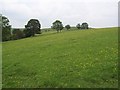
Pasture west of Cowper Cote
Lovely floral pasture by Calton Gill, near Cowper Cote Farm
Image: © Chris Heaton
Taken: 28 Jun 2006
0.17 miles
9
Stile on path between Cowper Cote & lane bridge over Winterburn Beck
The stile is located a little further south west to what is shown on the map.
Image: © Colin Park
Taken: 27 Mar 2022
0.22 miles
10
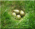
Curlew's nest
A vulnerable clutch of eggs by a footpath.
Image: © John Illingworth
Taken: 14 May 2008
0.23 miles