IMAGES TAKEN NEAR TO
Quincy Close, BRADFORD, BD2 2EP
Introduction
This page details the photographs taken nearby to Quincy Close, BD2 2EP by members of the Geograph project.
The Geograph project started in 2005 with the aim of publishing, organising and preserving representative images for every square kilometre of Great Britain, Ireland and the Isle of Man.

There are currently over 7.5m images from over14,400 individuals and you can help contribute to the project by visiting https://www.geograph.org.uk
Image Map (Loading...)


Getting Data...Please wait
Leaflet Map data © OpenStreetMap
Images are licensed for reuse under creativecommons.org/licenses/by-sa/2.0
Notes
- Clicking on the map will re-center to the selected point.
- The higher the marker number, the further away the image location is from the centre of the postcode.
Image Listing (123 Images Found)
Images are licensed for reuse under creativecommons.org/licenses/by-sa/2.0
Image
Details
Distance
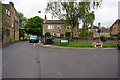
2
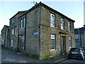
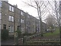
Aysgarth House, Tunwell Lane, Eccleshill
According to a local history leaflet, the lane dates back to 1618 and was so named because it was close to the “town well”.
Image: © Stephen Craven
Taken: 30 Nov 2019
0.03 miles
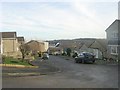
9
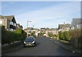
Moorwell Place - viewed from Moorside Road
Image: © Betty Longbottom
Taken: 11 Dec 2010
0.06 miles
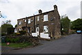
10
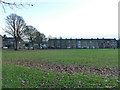
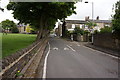
Eccleshill recreation ground
According to a local history leaflet, a court case in 1864 established that the three-acre recreation ground "must remain intact forever".
Image: © Stephen Craven
Taken: 30 Nov 2019
0.06 miles