IMAGES TAKEN NEAR TO
Dodgson Lane, KEIGHLEY, BD20 8FR
Introduction
This page details the photographs taken nearby to Dodgson Lane, BD20 8FR by members of the Geograph project.
The Geograph project started in 2005 with the aim of publishing, organising and preserving representative images for every square kilometre of Great Britain, Ireland and the Isle of Man.

There are currently over 7.5m images from over14,400 individuals and you can help contribute to the project by visiting https://www.geograph.org.uk
Image Map
Images are licensed for reuse under creativecommons.org/licenses/by-sa/2.0
Notes
- Clicking on the map will re-center to the selected point.
- The higher the marker number, the further away the image location is from the centre of the postcode.
Image Listing (12 Images Found)
Images are licensed for reuse under creativecommons.org/licenses/by-sa/2.0
Image
Details
Distance
1
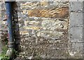
Lothersdale, Dodgson House Farm
A close up view of the old stone farm building, with the more recent add-on, a dairy for storing and refrigerating milk, to the right. Today the farm is not milking cows, but runs suckler cows and a sheep flock. To the right of the drainpipe is a worn benchmark, with part of the arrowheads filled with moss and cement.
Image: © Mel Towler
Taken: 16 Jun 2021
0.00 miles
2
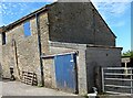
Lothersdale, Dodgson House Farm
The old stone farm building and more recent add-on [1970's] of the more modern dairy on the extreme right. Today the farm is not milking cows, but runs suckler cows and a sheep flock. To the right of the drainpipe is a worn benchmark.
Image: © Mel Towler
Taken: 16 Jun 2021
0.01 miles
3
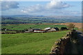
Dodgsons Farm
On the western slopes of Thornton Moor with views to Ingleborough.
Image: © Bill Boaden
Taken: 7 Oct 2011
0.01 miles
4
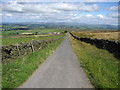
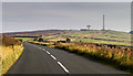
Dodgson Lane
Gives access from Dodgsons Farm to the Skipton/Colne moor road. It affords fabulous views across the Aire Gap, with Pen y Ghent and Ingleborough visible on the skyline.
Image: © Chris Heaton
Taken: 7 Aug 2007
0.10 miles
5
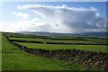
Walls and green fields and a shower out of the blue
These fields are above Dodgsons Farm. The view faces west towards Pendle. The rain shower appeared to generate itself out of nowhere.
Image: © Bill Boaden
Taken: 7 Oct 2011
0.13 miles
6
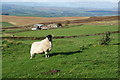
Sheep above Dodgsons Farm
Taken from the path along the side of Dodgson Allotment.
Image: © Bill Boaden
Taken: 7 Oct 2011
0.20 miles
7
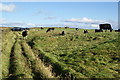
Cows on Dodgson Allotment
The silage bales ahead are protected from marauding by an electric fence.
Image: © Bill Boaden
Taken: 7 Oct 2011
0.21 miles
8
Dodgson Allotment
High Pasture just off the moor road that connects Colne to Skipton. Pendle Hill can be seen in the distance.
Image: © Chris Heaton
Taken: 7 Aug 2007
0.22 miles
9
Thornton Moor
Road Crossing Thornton Moor.
Image: © Peter McDermott
Taken: 10 Oct 2015
0.23 miles
10
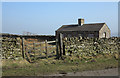
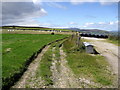
Small building at wall corner
The nearer wall with the wooden gate is on Dodgson Lane which is one of those curious ways recorded on OS maps as "(an)other route with public access". The building at the angle of the walls is not shown on OS maps at any scale yet has the appearance of being old. A minor public road lies beyond the farther wall.
Image: © Trevor Littlewood
Taken: 5 Mar 2013
0.23 miles