IMAGES TAKEN NEAR TO
Robin Walk, SHIPLEY, BD18 2EF
Introduction
This page details the photographs taken nearby to Robin Walk, BD18 2EF by members of the Geograph project.
The Geograph project started in 2005 with the aim of publishing, organising and preserving representative images for every square kilometre of Great Britain, Ireland and the Isle of Man.

There are currently over 7.5m images from over14,400 individuals and you can help contribute to the project by visiting https://www.geograph.org.uk
Image Map (Loading...)


Getting Data...Please wait
Leaflet Map data © OpenStreetMap
Images are licensed for reuse under creativecommons.org/licenses/by-sa/2.0
Notes
- Clicking on the map will re-center to the selected point.
- The higher the marker number, the further away the image location is from the centre of the postcode.
Image Listing (94 Images Found)
Images are licensed for reuse under creativecommons.org/licenses/by-sa/2.0
Image
Details
Distance
2
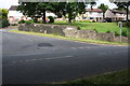
Junction of Hollin Lane and Festival Avenue
Image: © Roger Templeman
Taken: 29 Jun 2015
0.06 miles
3
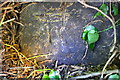
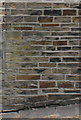
Benchmark on Hollin Lane wall
Ordnance Survey cut mark benchmark described on the Bench Mark Database at http://www.bench-marks.org.uk/bm84751
Image: © Roger Templeman
Taken: 26 May 2017
0.06 miles
4
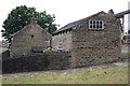
#131 Crag Road ('Hollin Cottage') and its outbuilding
There is an OS benchmark Image on the outbuilding about 3ft. right of its junction with the house's garden wall
Image: © Roger Templeman
Taken: 29 Jun 2015
0.08 miles
5
Benchmark on outbuilding of #131 Crag Road
Ordnance Survey cut mark described on the Bench Mark Database at http://www.bench-marks.org.uk/bm71160
Image: © Roger Templeman
Taken: 29 Jun 2015
0.08 miles
6
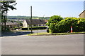
Junction of Hollin Lane and Festival Avenue
There is an OS benchmark Image behind the ivy on the stone wall left of the traffic cone
Image: © Roger Templeman
Taken: 26 May 2017
0.08 miles
9
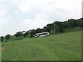
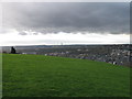
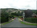
Carr Lane
The only way from Shipley up to Wrose is via the steep hill of Carr Lane, which crosses the open land shown here. The hill gives panoramic views of Frizinghall, Shipley, Saltaire and Baildon.
Image: © David Spencer
Taken: 7 Jul 2005
0.11 miles
10
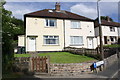
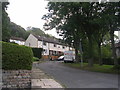
Semi-detached houses on Douglas Crescent
There is an OS benchmark Image on the left hand side of the house at its front corner, by the wheelie bins
Image: © Roger Templeman
Taken: 29 Jun 2015
0.12 miles