IMAGES TAKEN NEAR TO
Cotswold Avenue, SHIPLEY, BD18 1LS
Introduction
This page details the photographs taken nearby to Cotswold Avenue, BD18 1LS by members of the Geograph project.
The Geograph project started in 2005 with the aim of publishing, organising and preserving representative images for every square kilometre of Great Britain, Ireland and the Isle of Man.

There are currently over 7.5m images from over14,400 individuals and you can help contribute to the project by visiting https://www.geograph.org.uk
Image Map
Images are licensed for reuse under creativecommons.org/licenses/by-sa/2.0
Notes
- Clicking on the map will re-center to the selected point.
- The higher the marker number, the further away the image location is from the centre of the postcode.
Image Listing (77 Images Found)
Images are licensed for reuse under creativecommons.org/licenses/by-sa/2.0
Image
Details
Distance
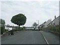
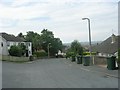
1
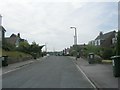
Cotswold Avenue - looking towards Westfield Lane
Image: © Betty Longbottom
Taken: 5 Jul 2011
0.01 miles
4
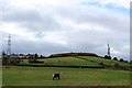
Idle Hill
View towards the summit of Idle Hill - which used to be a covered service reservoir.
To the west are masts of a relay station connected to Emley Moor.
Image: © Chris Heaton
Taken: 12 Jan 2016
0.07 miles
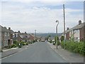
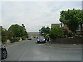
6
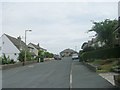
West View Avenue - viewed from High Ash
Image: © Betty Longbottom
Taken: 5 Jul 2011
0.08 miles
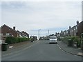
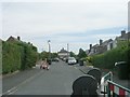
9
West View Avenue - viewed from High Ash
Image: © Betty Longbottom
Taken: 5 Jul 2011
0.10 miles
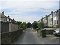
10
High Ash - viewed from Spring Hill
Image: © Betty Longbottom
Taken: 5 Jul 2011
0.10 miles