IMAGES TAKEN NEAR TO
Cliffe Lane, SHIPLEY, BD17 5JT
Introduction
This page details the photographs taken nearby to Cliffe Lane, BD17 5JT by members of the Geograph project.
The Geograph project started in 2005 with the aim of publishing, organising and preserving representative images for every square kilometre of Great Britain, Ireland and the Isle of Man.

There are currently over 7.5m images from over14,400 individuals and you can help contribute to the project by visiting https://www.geograph.org.uk
Image Map
Images are licensed for reuse under creativecommons.org/licenses/by-sa/2.0
Notes
- Clicking on the map will re-center to the selected point.
- The higher the marker number, the further away the image location is from the centre of the postcode.
Image Listing (197 Images Found)
Images are licensed for reuse under creativecommons.org/licenses/by-sa/2.0
Image
Details
Distance
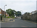
1
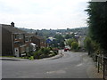
Cliffe Lane - viewed from Cliffe Terrace
Image: © Betty Longbottom
Taken: 2 Sep 2011
0.02 miles
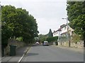

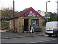
4
Steps leading up from Cliffe Terrace
Image: © Betty Longbottom
Taken: 2 Sep 2011
0.03 miles
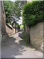
8
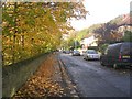
Southdown Road - looking towards Greenwood Road
Image: © Betty Longbottom
Taken: 28 Oct 2011
0.05 miles

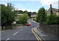
10
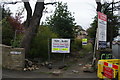
Site of a former church in Baildon
This site is intended to be developed for housing though it is close to a notoriously busy junction. I don't know what sort of church was here before.
Image: © Bill Boaden
Taken: 12 Apr 2014
0.06 miles