IMAGES TAKEN NEAR TO
Victoria Street, BINGLEY, BD16 2NH
Introduction
This page details the photographs taken nearby to Victoria Street, BD16 2NH by members of the Geograph project.
The Geograph project started in 2005 with the aim of publishing, organising and preserving representative images for every square kilometre of Great Britain, Ireland and the Isle of Man.

There are currently over 7.5m images from over14,400 individuals and you can help contribute to the project by visiting https://www.geograph.org.uk
Image Map (Loading...)


Getting Data...Please wait
Leaflet Map data © OpenStreetMap
Images are licensed for reuse under creativecommons.org/licenses/by-sa/2.0
Notes
- Clicking on the map will re-center to the selected point.
- The higher the marker number, the further away the image location is from the centre of the postcode.
Image Listing (278 Images Found)
Images are licensed for reuse under creativecommons.org/licenses/by-sa/2.0
Image
Details
Distance
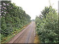
1
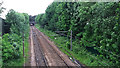
Railway north-west of Leonard Street
Looking towards Bingley station. See also Image
Image: © Stephen Craven
Taken: 6 Jun 2017
0.02 miles
2
Bridleway - Healey Lane, Bradford Road
Image: © Betty Longbottom
Taken: 13 Jan 2009
0.03 miles
3
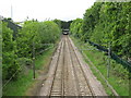
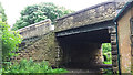
View North West from Bridge TJC3/60, B6429 Leonard Street
The Airedale Line, looking towards Bingley Tunnel, with the platforms of Bingley Station just visible through the tunnel. No trains today, due to track maintenance work between Shipley & Saltaire.
Image: © Stephen Armstrong
Taken: 15 May 2011
0.03 miles
4
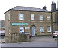
Yorkshire Centre of Classical Homeopathy - Bradford Road
Image: © Betty Longbottom
Taken: 24 Nov 2009
0.03 miles

6
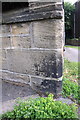
Benchmark on wall outside #181 Bradford Road
Ordnance Survey cut mark benchmark described on the Bench Mark Database at http://www.bench-marks.org.uk/bm38645
Image: © Roger Templeman
Taken: 30 Jun 2011
0.04 miles
7
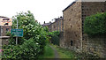
West end of Healey Lane, Bingley
The "lane" is shown on some maps as if it is a road, but in fact it is only of bridleway status, as indicated on this old sign. The warning "no unauthorised motor vehicles" is redundant, since this end is now so overgrown that you would have a job getting anything more than a mountain bike along this section. After the first 50 metres or so, it does become more accessible.
Image: © Stephen Craven
Taken: 6 Jun 2017
0.04 miles
8
View from Bridge TJC 3-60 - Leonard Street
Image: © Betty Longbottom
Taken: 20 Aug 2012
0.05 miles
9
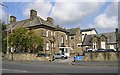
Bingley Police Station - Main Street
Image: © Betty Longbottom
Taken: 10 Oct 2007
0.05 miles
10
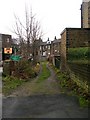
Steps from Healey Lane to Leonard Street
Some maps show Healey Lane (foreground) joining with Leonard Street, but in fact the latter crosses both the lane and the adjacent railway line by a bridge. The two are linked only by a steep flight of steps.
Image: © Stephen Craven
Taken: 6 Jun 2017
0.05 miles