IMAGES TAKEN NEAR TO
South Walk, BINGLEY, BD16 1BZ
Introduction
This page details the photographs taken nearby to South Walk, BD16 1BZ by members of the Geograph project.
The Geograph project started in 2005 with the aim of publishing, organising and preserving representative images for every square kilometre of Great Britain, Ireland and the Isle of Man.

There are currently over 7.5m images from over14,400 individuals and you can help contribute to the project by visiting https://www.geograph.org.uk
Image Map
Images are licensed for reuse under creativecommons.org/licenses/by-sa/2.0
Notes
- Clicking on the map will re-center to the selected point.
- The higher the marker number, the further away the image location is from the centre of the postcode.
Image Listing (76 Images Found)
Images are licensed for reuse under creativecommons.org/licenses/by-sa/2.0
Image
Details
Distance
4
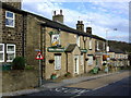
The Golden Fleece, Harden
The green Samuel Webster sign and livery was once a common and familiar sight throughout the Pennines in the West Riding. Now a rarity since the brewery shut in 1996.
Image: © al partington
Taken: 7 Nov 2006
0.05 miles
5

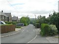
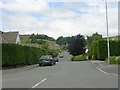
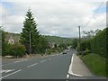
Valley View - looking towards Long Lane
Image: © Betty Longbottom
Taken: 20 Jul 2013
0.06 miles
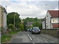
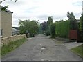
8
Long Lane - viewed from North Walk
Image: © Betty Longbottom
Taken: 22 Jun 2009
0.07 miles