IMAGES TAKEN NEAR TO
Harden Road, BINGLEY, BD16 1AX
Introduction
This page details the photographs taken nearby to Harden Road, BD16 1AX by members of the Geograph project.
The Geograph project started in 2005 with the aim of publishing, organising and preserving representative images for every square kilometre of Great Britain, Ireland and the Isle of Man.

There are currently over 7.5m images from over14,400 individuals and you can help contribute to the project by visiting https://www.geograph.org.uk
Image Map
Images are licensed for reuse under creativecommons.org/licenses/by-sa/2.0
Notes
- Clicking on the map will re-center to the selected point.
- The higher the marker number, the further away the image location is from the centre of the postcode.
Image Listing (15 Images Found)
Images are licensed for reuse under creativecommons.org/licenses/by-sa/2.0
Image
Details
Distance
1
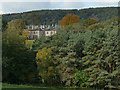
A glimpse of Harden Grange
Not to be confused with "Old Harden Grange" nearby, also known as St Ives, this is a later house of 1859, of which only the older stable block is listed.
Image: © Stephen Craven
Taken: 12 Oct 2019
0.01 miles
2
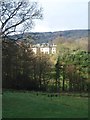
Harden Grange
Seen from the other side of Harden Beck, one only gets a glimpse of this large house which dates from 1759, although what can be seen from this angle is more likely to be part of the extensive rebuilding by W B Ferrand a hundred years later. The Pevsner guide describes it as 'totally undistinguished architecturally'.
Image: © Gordon Hatton
Taken: 11 Feb 2016
0.02 miles
3
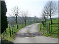
Driveway to Harden Grange - Harden Road
Image: © Betty Longbottom
Taken: 12 Apr 2010
0.14 miles
4
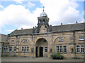
Coach House St.Ives estate Bingley
The former coach house on the St. Ives was built on land acquired by the Ferrands family in 1639, it is now a part of the Sports Turf Research Institute.
Image: © Mick Melvin
Taken: 20 Aug 2005
0.17 miles
5
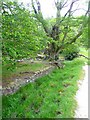
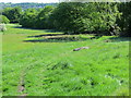
Haha and veteran tree, Cottingley Wood Estate
The ditch and wall do not look to be an effective barrier against cattle entering the woodland.
Image: © Humphrey Bolton
Taken: 25 May 2011
0.19 miles
7
Footpath approaching Cottingley Wood
Path adopted by the Aire/Calder Link ascending towards Cottingley Wood Estate.
Image: © Chris Heaton
Taken: 8 Nov 2013
0.21 miles
8
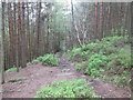
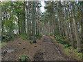
Path into Ruin Bank Wood
A public footpath from Bingley to Wilsden, part of the Bradford Millennium Way.
Image: © Stephen Craven
Taken: 12 Oct 2019
0.21 miles
9
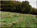
Footpath - Millennium Way - descending to Shipley Golf Course
Looking north-eastward.
Image: © Peter Wood
Taken: 24 May 2016
0.22 miles
10
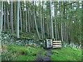
Path junction in Ruin Bank Wood
The public footpath (Bradford Millennium Way) heads uphill to the left; to the right is a more level forestry track.
Image: © Stephen Craven
Taken: 12 Oct 2019
0.23 miles