IMAGES TAKEN NEAR TO
Turf Lane, BRADFORD, BD13 5JT
Introduction
This page details the photographs taken nearby to Turf Lane, BD13 5JT by members of the Geograph project.
The Geograph project started in 2005 with the aim of publishing, organising and preserving representative images for every square kilometre of Great Britain, Ireland and the Isle of Man.

There are currently over 7.5m images from over14,400 individuals and you can help contribute to the project by visiting https://www.geograph.org.uk
Image Map
Images are licensed for reuse under creativecommons.org/licenses/by-sa/2.0
Notes
- Clicking on the map will re-center to the selected point.
- The higher the marker number, the further away the image location is from the centre of the postcode.
Image Listing (6 Images Found)
Images are licensed for reuse under creativecommons.org/licenses/by-sa/2.0
Image
Details
Distance
1
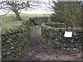
Obstructed bridleway
The wall and stile were built across the bridleway in the 1980s. Bradford council are now trying to downgrade the status to footpath
Image: © John Slater
Taken: 8 Jan 2012
0.07 miles
2
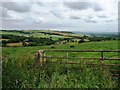
Sugden House from Staples Brow
The hillside drops steeply about 100 metres to this house.
Image: © Christine Johnstone
Taken: 13 Jul 2011
0.21 miles
3
![Grassy field [2]](https://s3.geograph.org.uk/geophotos/02/50/57/2505735_d0e82d39_120x120.jpg)
Grassy field [2]
On the west side of Keighley Road.
Image: © Christine Johnstone
Taken: 13 Jul 2011
0.24 miles
4
![Grassy field [1]](https://s0.geograph.org.uk/geophotos/02/50/57/2505728_0fd5f416_120x120.jpg)
Grassy field [1]
On the west side of Keighley Road.
Image: © Christine Johnstone
Taken: 13 Jul 2011
0.24 miles
5
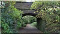
Former Railway Bridge
North of the former Cullingworth Station. A private farm track is on the line of the railway trackbed and a bridleway passes through the arch leading into Ellar Carr Clough
Image: © Kevin Waterhouse
Taken: 27 Oct 2021
0.24 miles
6
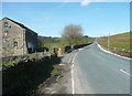
Keighley Road, Cullingworth, at Ellar Carr
Image: © Humphrey Bolton
Taken: 5 Apr 2018
0.25 miles