IMAGES TAKEN NEAR TO
Hunters Green, BRADFORD, BD13 5JH
Introduction
This page details the photographs taken nearby to Hunters Green, BD13 5JH by members of the Geograph project.
The Geograph project started in 2005 with the aim of publishing, organising and preserving representative images for every square kilometre of Great Britain, Ireland and the Isle of Man.

There are currently over 7.5m images from over14,400 individuals and you can help contribute to the project by visiting https://www.geograph.org.uk
Image Map
Images are licensed for reuse under creativecommons.org/licenses/by-sa/2.0
Notes
- Clicking on the map will re-center to the selected point.
- The higher the marker number, the further away the image location is from the centre of the postcode.
Image Listing (17 Images Found)
Images are licensed for reuse under creativecommons.org/licenses/by-sa/2.0
Image
Details
Distance
1
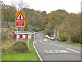
Welcome to Cullingworth
The welcome stone is relatively recent (in that it does not currently appear on the Streetview image dated 2008).
Image: © Stephen Craven
Taken: 28 Oct 2017
0.07 miles
2
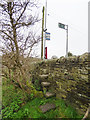
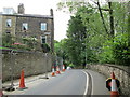
Steps up to Bingley Road, Cullingworth
The steps are where a public footpath emerges onto the main road. There is also a bus stop here, though I imagine no-one walks a mile across the valley from Wilsden to catch an infrequent bus from here.
Image: © Stephen Craven
Taken: 28 Oct 2017
0.08 miles
3
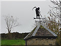
The grim reaper, Woodfield Mill, Cullingworth
A weathervane on a converted mill Image
Image: © Stephen Craven
Taken: 28 Oct 2017
0.11 miles
4
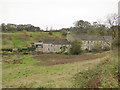
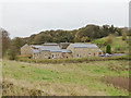
Woodfield Mill, Cullingworth
A former industrial building, now converted to housing.
Image: © Stephen Craven
Taken: 28 Oct 2017
0.11 miles
5
New housing, Woodfield Road, Cullingworth
Viewed from Bingley Road.
Image: © Stephen Craven
Taken: 28 Oct 2017
0.11 miles
6
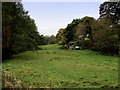
Pasture beside Cow House Beck
A little enclave of countryside to the north of Cullingworth as seen from the B6429.
Image: © Chris Heaton
Taken: 8 Nov 2013
0.13 miles
7

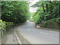
Hill End Lane (B6429) near to Cow House Bridge
Looking south-westward towards Cullingworth.
Image: © Peter Wood
Taken: 9 Jan 2019
0.14 miles
8
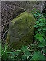
Old Guide Stone by the B6429, Bingley Road, Cullingworth Parish
By the B6429, in parish of Cullingworth (Bradford District), Bingley Road junction with Bridleway named Dolphin Lane, at corner of wall, South West side of lane, above Cow House Farm.
Inscription of {pointing hand} is clear
Surveyed
Milestone Society National ID: YW_XCUL.
Image: © Milestone Society
Taken: Unknown
0.17 miles
9
Bingley Road - viewed from Halifax Road
Image: © Betty Longbottom
Taken: 30 May 2014
0.21 miles
10
Keighley Road - viewed from Bingley Road
Image: © Betty Longbottom
Taken: 30 May 2014
0.22 miles