IMAGES TAKEN NEAR TO
Stocks Lane, BRADFORD, BD13 2RJ
Introduction
This page details the photographs taken nearby to Stocks Lane, BD13 2RJ by members of the Geograph project.
The Geograph project started in 2005 with the aim of publishing, organising and preserving representative images for every square kilometre of Great Britain, Ireland and the Isle of Man.

There are currently over 7.5m images from over14,400 individuals and you can help contribute to the project by visiting https://www.geograph.org.uk
Image Map (Loading...)


Getting Data...Please wait
Leaflet Map data © OpenStreetMap
Images are licensed for reuse under creativecommons.org/licenses/by-sa/2.0
Notes
- Clicking on the map will re-center to the selected point.
- The higher the marker number, the further away the image location is from the centre of the postcode.
Image Listing (89 Images Found)
Images are licensed for reuse under creativecommons.org/licenses/by-sa/2.0
Image
Details
Distance
1
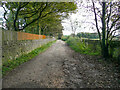
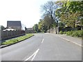
Stocks Lane, Clayton
Presumably this lane has not been adopted and surfaced by the council because it only goes to Low House.
Image: © Humphrey Bolton
Taken: 8 Oct 2020
0.07 miles
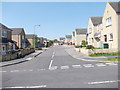
4

Dunnock Avenue - Sheila Henry Drive
Image: © Betty Longbottom
Taken: 22 May 2012
0.09 miles
8

Pollits House - off Dunnock Avenue
Built in 1902 - currently derelict - last used by Bradford NHS Trust.
Image: © Betty Longbottom
Taken: 22 May 2012
0.10 miles
10
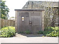
Electricity Substation No 1672 - Sheila Henry Drive
Image: © Betty Longbottom
Taken: 22 May 2012
0.12 miles