IMAGES TAKEN NEAR TO
Hainsworth Moor Garth, BRADFORD, BD13 2NE
Introduction
This page details the photographs taken nearby to Hainsworth Moor Garth, BD13 2NE by members of the Geograph project.
The Geograph project started in 2005 with the aim of publishing, organising and preserving representative images for every square kilometre of Great Britain, Ireland and the Isle of Man.

There are currently over 7.5m images from over14,400 individuals and you can help contribute to the project by visiting https://www.geograph.org.uk
Image Map
Images are licensed for reuse under creativecommons.org/licenses/by-sa/2.0
Notes
- Clicking on the map will re-center to the selected point.
- The higher the marker number, the further away the image location is from the centre of the postcode.
Image Listing (94 Images Found)
Images are licensed for reuse under creativecommons.org/licenses/by-sa/2.0
Image
Details
Distance
1
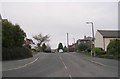
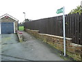
Hainsworth Moor Drive - Hill End Lane
Image: © Betty Longbottom
Taken: 27 Dec 2008
0.03 miles
2
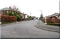
Hainsworth Moor Crescent - Hainsworth Moor Drive
Image: © Betty Longbottom
Taken: 27 Dec 2008
0.04 miles
3
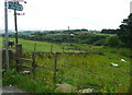
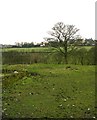
Footpath off Hill End Lane, Queensbury
Only the first section of this path is on its definitive route as shown on the Bradford Council rights-of-way map and OS maps. This was a path to a farm called Green Field, which was in the area of rough vegetation beyond the corner of the wall.
Image: © Humphrey Bolton
Taken: 27 Jun 2016
0.05 miles
4
Hainsworth Moor View - Hainsworth Moor Drive
Image: © Betty Longbottom
Taken: 19 Sep 2009
0.05 miles
5
Queensbury FP26 at Hainsworth Moor Grove
Image: © Humphrey Bolton
Taken: 6 Feb 2017
0.06 miles
6
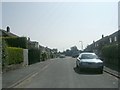
Footpath - Hill End Lane to Shibden Head
Image: © Betty Longbottom
Taken: 27 Dec 2008
0.07 miles
7
Ford Hill Recycling Plant - Hill End Lane
Image: © Betty Longbottom
Taken: 19 Sep 2009
0.08 miles
8
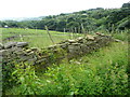
Footpath at the site of Green Field, Queensbury
The 1893 1:2500 map shows the path that starts at Image as leaving the farmyard at the corner at the right-hand end of this wall. There is a barbed wire fence and no stile.
Image: © Humphrey Bolton
Taken: 27 Jun 2016
0.08 miles
9
Diversion route for blocked footpath off Hill End Lane, Queensbury
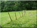
From the site of Green Field, see Image, where the definitive route is blocked, the obvious diversion to try is to follow this fence with the hope of turning left between the fence and the trees to rejoin the right-of-way. However that is not possible and one has to veer to the right and cross the stream via the mound shown in Image
Image: © Humphrey Bolton
Taken: 27 Jun 2016
0.08 miles
10
Hainsworth Moor Crescent - Hainsworth Moor View
Image: © Betty Longbottom
Taken: 19 Sep 2009
0.08 miles