IMAGES TAKEN NEAR TO
Albion Street, BRADFORD, BD13 2HA
Introduction
This page details the photographs taken nearby to Albion Street, BD13 2HA by members of the Geograph project.
The Geograph project started in 2005 with the aim of publishing, organising and preserving representative images for every square kilometre of Great Britain, Ireland and the Isle of Man.

There are currently over 7.5m images from over14,400 individuals and you can help contribute to the project by visiting https://www.geograph.org.uk
Image Map
Images are licensed for reuse under creativecommons.org/licenses/by-sa/2.0
Notes
- Clicking on the map will re-center to the selected point.
- The higher the marker number, the further away the image location is from the centre of the postcode.
Image Listing (165 Images Found)
Images are licensed for reuse under creativecommons.org/licenses/by-sa/2.0
Image
Details
Distance
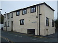
2
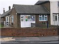
Queensbury Police & Community Contact Point - New Park Road
Image: © Betty Longbottom
Taken: 27 Dec 2008
0.02 miles
7
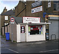
Stainthorpes Family Butchers - West End
Image: © Betty Longbottom
Taken: 2 Nov 2009
0.05 miles
8
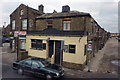
The pub with no name?
Actually formerly the West End Tavern. On the main road through Queensbury, next to JK Off Licence and Grocers. To the right is Alma Street.
Google's Street View photos from August 2009 suggest the pub was then still open although the sign outside was advertising a Christmas-themed party - in July - as if to suggest that it wouldn't be around come December. When I passed that way in February 2012 the sign was blacked out and the windows too were boarded up and painted black, as if in mourning.
Image: © Phil Champion
Taken: 1 Feb 2012
0.05 miles
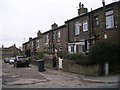
9
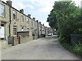
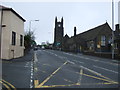
Charles Street -looking towards Commercial Street
Image: © Betty Longbottom
Taken: 19 Jun 2013
0.06 miles