IMAGES TAKEN NEAR TO
Greenton Crescent, BRADFORD, BD13 2AZ
Introduction
This page details the photographs taken nearby to Greenton Crescent, BD13 2AZ by members of the Geograph project.
The Geograph project started in 2005 with the aim of publishing, organising and preserving representative images for every square kilometre of Great Britain, Ireland and the Isle of Man.

There are currently over 7.5m images from over14,400 individuals and you can help contribute to the project by visiting https://www.geograph.org.uk
Image Map (Loading...)


Getting Data...Please wait
Leaflet Map data © OpenStreetMap
Images are licensed for reuse under creativecommons.org/licenses/by-sa/2.0
Notes
- Clicking on the map will re-center to the selected point.
- The higher the marker number, the further away the image location is from the centre of the postcode.
Image Listing (93 Images Found)
Images are licensed for reuse under creativecommons.org/licenses/by-sa/2.0
Image
Details
Distance
1
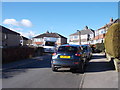
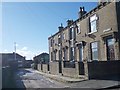
Greenton Crescent - Greenland Avenue
Image: © Betty Longbottom
Taken: 2 Feb 2013
0.02 miles
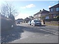
2
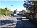
Greenland Villas - Greenland Avenue
Image: © Betty Longbottom
Taken: 2 Feb 2013
0.04 miles
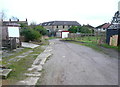
3
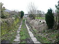
Queensbury FP27 on an old flagged cart track
The track went to Hainsworth Moor Farm.
Image: © Humphrey Bolton
Taken: 6 Feb 2017
0.04 miles
4
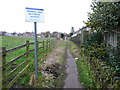
Misleading sign on Queensbury FP27
This should be facing the land at the side, not the public footpath.
Image: © Humphrey Bolton
Taken: 6 Feb 2017
0.05 miles
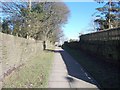
7
Queensbury FP27
Here the footpath is along a broad track off which are some garages.
Image: © Humphrey Bolton
Taken: 6 Feb 2017
0.06 miles
9
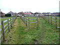
Queensbury FP86
This path has two branches, which seems to have originated as short cuts across what was quarry land. Presumably the paths were successfully claimed as public footpaths, and perhaps the council want to let the land for grazing, but the expensive fencing seems a bit 'over the top'.
Image: © Humphrey Bolton
Taken: 6 Feb 2017
0.08 miles
10
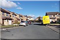
Upper Meadows - Micklethwaite Drive
Image: © Betty Longbottom
Taken: 2 Feb 2013
0.08 miles