IMAGES TAKEN NEAR TO
Naseby Rise, BRADFORD, BD13 1QP
Introduction
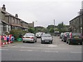
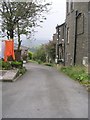
This page details the photographs taken nearby to Naseby Rise, BD13 1QP by members of the Geograph project.
The Geograph project started in 2005 with the aim of publishing, organising and preserving representative images for every square kilometre of Great Britain, Ireland and the Isle of Man.

There are currently over 7.5m images from over14,400 individuals and you can help contribute to the project by visiting https://www.geograph.org.uk
Image Map
Images are licensed for reuse under creativecommons.org/licenses/by-sa/2.0
Notes
- Clicking on the map will re-center to the selected point.
- The higher the marker number, the further away the image location is from the centre of the postcode.
Image Listing (144 Images Found)
Images are licensed for reuse under creativecommons.org/licenses/by-sa/2.0
Image
Details
Distance
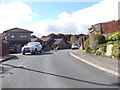
4
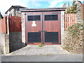
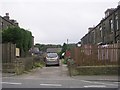
Electricity Substation No 3173 - Naseby Rise
Image: © Betty Longbottom
Taken: 6 Oct 2012
0.05 miles
10
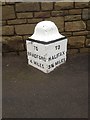
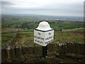
Old Milestone by the A647, Scarlet Heights, Bradford
Carved stone post by the A647, in parish of BRADFORD (BRADFORD District), Scarlet Heights, quarter mile East of A644 crossroads; opposite Rock Lea, in front of new stone wall, between lampposts 129 and 130, on North side of road. Previously on top of old low stone wall. Erected by the Leeds & Halifax turnpike wall trust in the 18th century.
Inscription reads:-
: TO / BRADFORD / 4 MILES : : TO / HALIFAX / 3¾ MILES :
Grade II Listed. List Entry Number: 1133590
https://historicengland.org.uk/listing/the-list/list-entry/1133590
Milestone Society National ID: YW_HABF04.
Image: © C Minto
Taken: Unknown
0.06 miles