IMAGES TAKEN NEAR TO
North View, BRADFORD, BD13 1LL
Introduction
This page details the photographs taken nearby to North View, BD13 1LL by members of the Geograph project.
The Geograph project started in 2005 with the aim of publishing, organising and preserving representative images for every square kilometre of Great Britain, Ireland and the Isle of Man.

There are currently over 7.5m images from over14,400 individuals and you can help contribute to the project by visiting https://www.geograph.org.uk
Image Map
Images are licensed for reuse under creativecommons.org/licenses/by-sa/2.0
Notes
- Clicking on the map will re-center to the selected point.
- The higher the marker number, the further away the image location is from the centre of the postcode.
Image Listing (56 Images Found)
Images are licensed for reuse under creativecommons.org/licenses/by-sa/2.0
Image
Details
Distance
1
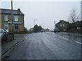
Glazier Road - Brighouse & Denholme Road
Image: © Betty Longbottom
Taken: 19 Jun 2013
0.02 miles
2
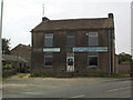
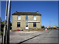
Bradford Sub Aqua Club, Mountain
At Mountain near Queensbury, altitude 1224ft, is the Bradford Sub Aqua Club. It does seem a tiny bit odd until you remember that it rains a lot up there.
Image: © David Spencer
Taken: 18 Aug 2005
0.03 miles
3
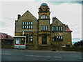
Mountain Hall, Queensbury
This is a revisit to the subject of the first geograph for the square: Image The building was built as the Speak Institute, and was recently a hotel. I have a vague memory that it might have been the offices of the Mountain Press, which published facsimiles of 19C local history books, but I have not been able to confirm this. The main change since 2005 is that a bus shelter has appeared.
Image: © Humphrey Bolton
Taken: 10 Jun 2021
0.04 miles
7
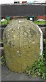
Old Boundary Marker by the A644, Brighouse and Denholme Road, Queensbury parish
Parish Boundary Marker by the A644, in parish of Queensbury (Bradford District), Brighouse and Denholme Road, Mountain, on pavement, against wall of No.45, next to YW_QUEE05pb Image
Surveyed
Milestone Society National ID: YW_QUEE04pb
Image: © Milestone Society
Taken: Unknown
0.05 miles
8

Old Boundary Marker by the A644, Brighouse and Denholme Road, Queensbury parish
Parish Boundary Marker by the A644, in parish of Queensbury (Bradford District), Brighouse and Denholme Road, Mountain, on pavement, against wall of No.45, North side of road, next to YW_QUEE04pb Image
Surveyed
Milestone Society National ID: YW_QUEE05pb
Image: © Milestone Society
Taken: Unknown
0.05 miles
9
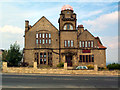
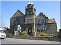
Mountain Hall, Mountain
According to an inscription, this was once the "Speak Institute, built by John Speak in memory of his father and mother, 1813". Most recently a hotel, it is being refurbished.
Image: © David Spencer
Taken: 18 Aug 2005
0.05 miles
10

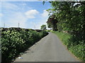
A View Northwards from Mountain
From my lofty position in Mountain, near Queensbury there are far reaching views over the Pinch Beck Valley towards Thornton.
Image: © Chris Heaton
Taken: 21 Mar 2017
0.06 miles