IMAGES TAKEN NEAR TO
Uplands Avenue, BRADFORD, BD13 1ER
Introduction
This page details the photographs taken nearby to Uplands Avenue, BD13 1ER by members of the Geograph project.
The Geograph project started in 2005 with the aim of publishing, organising and preserving representative images for every square kilometre of Great Britain, Ireland and the Isle of Man.

There are currently over 7.5m images from over14,400 individuals and you can help contribute to the project by visiting https://www.geograph.org.uk
Image Map
Images are licensed for reuse under creativecommons.org/licenses/by-sa/2.0
Notes
- Clicking on the map will re-center to the selected point.
- The higher the marker number, the further away the image location is from the centre of the postcode.
Image Listing (71 Images Found)
Images are licensed for reuse under creativecommons.org/licenses/by-sa/2.0
Image
Details
Distance
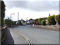
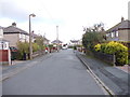
2
Uplands Avenue - looking towards Highgate Road
Image: © Betty Longbottom
Taken: 6 Oct 2012
0.04 miles
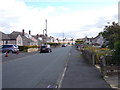
6
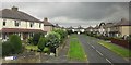
Uplands Avenue, Clayton Heights
Here's something you wouldn't get in a new development. As the road name indicates, this is a cul-de-sac - it also leads to Uplands Grove and Uplands Crescent. Meanwhile, just up the A647 is Uplands Close, also a cul-de-sac. Such a recipe for confusion would be proscribed by today's planners.
Image: © Derek Harper
Taken: 3 Jul 2014
0.09 miles
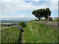
7
Bronte Way heading North off Back Lane
The long distance footpath leaving the fleshpots of Clayton Heights, heading north towards Thornton.
Image: © Chris Heaton
Taken: 26 Aug 2016
0.09 miles
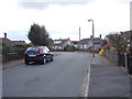
8
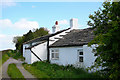
Mixed bag of houses at Clayton Heights
This is Back Lane at Clayton Heights, viewed from the corner of Lytham Drive. There is absolutely no uniformity of buildings at that side of the road, ranging from nineteenth century two and three storey houses to twentieth century bungalows. Who knows what possessed the builder to create a three storey house at this exposed site 1060ft above sea level.
Image: © David Spencer
Taken: 18 Aug 2005
0.10 miles
9
Uplands Grove - looking towards Uplands Avenue
Image: © Betty Longbottom
Taken: 6 Oct 2012
0.10 miles
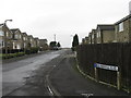
10
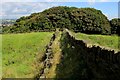
Sheep Hill Lane, Clayton
This lane has a 30mph speed limit sign at the end, so is presumably a public road. It has good views. The geraniums are probably a garden escape.
Image: © Humphrey Bolton
Taken: 24 Jun 2010
0.10 miles