IMAGES TAKEN NEAR TO
Penfield Road, BRADFORD, BD11 1ES
Introduction
This page details the photographs taken nearby to Penfield Road, BD11 1ES by members of the Geograph project.
The Geograph project started in 2005 with the aim of publishing, organising and preserving representative images for every square kilometre of Great Britain, Ireland and the Isle of Man.

There are currently over 7.5m images from over14,400 individuals and you can help contribute to the project by visiting https://www.geograph.org.uk
Image Map (Loading...)


Getting Data...Please wait
Leaflet Map data © OpenStreetMap
Images are licensed for reuse under creativecommons.org/licenses/by-sa/2.0
Notes
- Clicking on the map will re-center to the selected point.
- The higher the marker number, the further away the image location is from the centre of the postcode.
Image Listing (96 Images Found)
Images are licensed for reuse under creativecommons.org/licenses/by-sa/2.0
Image
Details
Distance
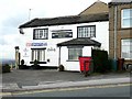
1
An unusual house number plate
The owner of 32 Penfield Road has acquired what appears to be an old railway bridge plate, as it bears the distance 183 miles 33 chains. A bit of detective work suggests this may have adorned a bridge over Gelderd Road on the former LMSR route into Leeds at Image That bridge has long since been demolished, so this appears to be a legitimate souvenir.
Image: © Stephen Craven
Taken: 15 Jun 2020
0.02 miles
3
Drighlington A.R.L F.C, Wakefield Road
They don't seem to use their full name, but I suppose the letters stand for 'Amateur Rugby League Football Club'.
Image: © Humphrey Bolton
Taken: 30 Mar 2010
0.03 miles
4
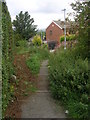
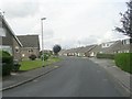
Steps from Moorside Walk to Penfield Road
Image: © Betty Longbottom
Taken: 23 Aug 2011
0.03 miles
5
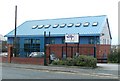
Windsor House Group Practice, Wakefield Road, Drighlington
Image: © Humphrey Bolton
Taken: 30 Mar 2010
0.04 miles
6
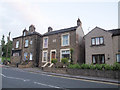
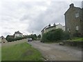
Houses on King Street, Adwalton
The centre property is called Coronation House and dated 1902 (hence, the coronation of Edward VII is referred to in the name).
Image: © Stephen Craven
Taken: 18 Jun 2015
0.04 miles
7
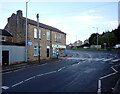
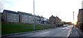
The B6135 changing from King Street to Wakefield Road, Drighlington
Image: © habiloid
Taken: 29 Dec 2021
0.04 miles
8
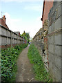
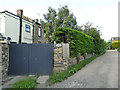
Footpath from Penfield Road to Moorside Vale
Like many such urban footpaths this one is a right of way that follows the line of a field-edge path predating modern housing development. The wall to the right (beyond the concrete blocks on the foreground) appears to be the old field wall.
Image: © Stephen Craven
Taken: 15 Jun 2020
0.04 miles