IMAGES TAKEN NEAR TO
Harrogate Road, BRADFORD, BD10 0QY
Introduction
This page details the photographs taken nearby to Harrogate Road, BD10 0QY by members of the Geograph project.
The Geograph project started in 2005 with the aim of publishing, organising and preserving representative images for every square kilometre of Great Britain, Ireland and the Isle of Man.

There are currently over 7.5m images from over14,400 individuals and you can help contribute to the project by visiting https://www.geograph.org.uk
Image Map
Images are licensed for reuse under creativecommons.org/licenses/by-sa/2.0
Notes
- Clicking on the map will re-center to the selected point.
- The higher the marker number, the further away the image location is from the centre of the postcode.
Image Listing (138 Images Found)
Images are licensed for reuse under creativecommons.org/licenses/by-sa/2.0
Image
Details
Distance
1
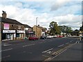
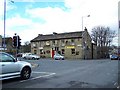
Harrogate Road, Greengates, Bradford
The A658 looking north, approaching the crossroads with the A657.
Image: © Stephen Armstrong
Taken: 14 Sep 2023
0.01 miles
2
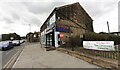
FonePeople, #919 Harrogate Road
Ordnance Survey documents indicate that a benchmark levelled at 90.858m above Newlyn Datum was verified in 1957 on a garage previously attached to the near side of the shop
Image: © Roger Templeman
Taken: 18 Aug 2024
0.01 miles
3
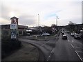
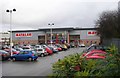
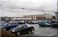
Entrance to retail park, Harrogate Road, Greengates
The retail park comprises 4.4 hectares and occupies the site of the former Holybrook Mills. It includes a Sainsbury's supermarket Image and Matalan, as well as the KFC seen here, a gym and smaller shops.
Taken from the top of a 670 bus to Bradford.
Image: © Stephen Craven
Taken: 16 Jan 2016
0.01 miles
4
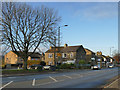
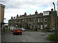
Houses and shops, Harrogate Road, Greengates
Stanley Street off to the left beyond the nearest house in this photo.
Image: © Stephen Craven
Taken: 30 Nov 2019
0.02 miles
5
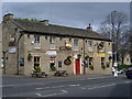
The Roebuck pub, Harrogate Road, Greengates
The traffic volume at the crossroads in the middle of Greengates village is so great that it was a challenge to take this picture with no vehicles obscuring it. Harrogate Road runs down from Undercliffe through Apperley Bridge and the other road is called the "New Line" and runs through Calverley and Idle between Leeds and Shipley, bisecting Greengates on the way.
Image: © Linden Milner
Taken: 19 Apr 2007
0.02 miles
6
Stanley Street, Greengates
Off Harrogate Road.
Image: © Richard Vince
Taken: 15 Sep 2022
0.03 miles
7
Matalan - Harrogate Road, Eccleshill
Image: © Betty Longbottom
Taken: 24 Nov 2007
0.03 miles
9
Sainsbury's - Harrogate Road, Eccleshill
Image: © Betty Longbottom
Taken: 24 Nov 2007
0.03 miles
10
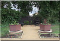
Greengates Community Garden
This is the new Greengates Community Garden, created in 2013. Between the Asda car park and the crossroads.
Image: © Linden Milner
Taken: 21 Feb 2014
0.05 miles