IMAGES TAKEN NEAR TO
Every Street, NELSON, BB9 7BF
Introduction
This page details the photographs taken nearby to Every Street, BB9 7BF by members of the Geograph project.
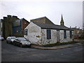
The Geograph project started in 2005 with the aim of publishing, organising and preserving representative images for every square kilometre of Great Britain, Ireland and the Isle of Man.

There are currently over 7.5m images from over14,400 individuals and you can help contribute to the project by visiting https://www.geograph.org.uk
Image Map
Images are licensed for reuse under creativecommons.org/licenses/by-sa/2.0
Notes
- Clicking on the map will re-center to the selected point.
- The higher the marker number, the further away the image location is from the centre of the postcode.
Image Listing (278 Images Found)
Images are licensed for reuse under creativecommons.org/licenses/by-sa/2.0
Image
Details
Distance
1
Ghausia Girls High School, Cross Street, Nelson
Single-sex education for secondary girls is very important to many Muslims, and the demand for it has led to this private high school being established.
Image: © Dr Neil Clifton
Taken: 7 Nov 2008
0.00 miles
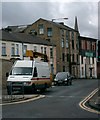
2

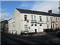
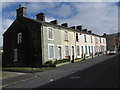
150 - 140 Every Street, Nelson
Just a few of the very many derelict terrace houses in this area, which are waiting to be demolished. In truth the houses are almost certainly beyond economic repair. But with the present recession, where the money will come from to rebuild the area is unclear, and it may remain derelict for many years.
Image: © Dr Neil Clifton
Taken: 7 Nov 2008
0.01 miles
3
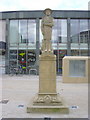
Boy Scouts' War Memorial, Nelson
"To the glorious memory of the Nelson Scouts who fell in the Great War."
Scout Memorial, Nelson, Lancashire - The memorial is of a young boy scout in full uniform and stands on the forecourt area between Nelson Town Centre Library, the Town Hall and the new Liberata Business Centre. It was recently refurbished to a high standard by Pendle Borough Council and is one of a few such statues in the UK which commemorates Scouting losses in the Great War
Wikipedia
Image: © Robert Wade
Taken: 28 Apr 2010
0.02 miles
4
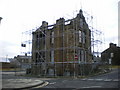
Former Presbytery on the corner of Macleod Street and Every Street
Image: © Alexander P Kapp
Taken: 16 Jan 2009
0.02 miles
5
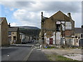
Macleod Street, Nelson, Lancashire
The ruined building is the remains of the presbytery attached to St. Joseph's Roman Catholic church, latterly a concrete building which occupied the vacant ground in the foreground of the picture. This had replaced an earlier building destroyed by fire in the 1960s. A great many houses on Macleod Street are awaiting demolition. The bridge just visible at the far end of the street is Whitefield Bridge 141 over the Leeds and Liverpool Canal, while on the skyline the familiar shape of Pendle Hill is visible.
Image: © Dr Neil Clifton
Taken: 5 Apr 2008
0.03 miles
6
Former scrap yard on the corner of Mosley Street and Every Street
Image: © Alexander P Kapp
Taken: 16 Jan 2009
0.03 miles
7
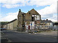
Macleod Street, Nelson, Lancashire
Things do not look good for Macleod Street. The ruin was formerly the presbytery attached to St. Joseph's RC Church, which latterly was a concrete building which was on the space in right foreground of the picture. This has replaced an earlier building destroyed by fire in the 1960s.
Image: © Dr Neil Clifton
Taken: 5 Apr 2008
0.03 miles
8
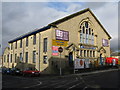
The Technology Centre, Nelson
Housed in what appears to be a former church
Image: © Dr Neil Clifton
Taken: 7 Nov 2008
0.03 miles
9
Nos. 16 to 2, Macleod Street, Nelson, Lancashire
Of this group of eight houses, seven are empty, boarded up and awaiting demolition. Only No 6, (which is extremely well kept) is still inhabited. At least, the resident has no trouble in finding a parking place for his car.
Image: © Dr Neil Clifton
Taken: 5 Apr 2008
0.03 miles
10
Nelson - Mills at St. Mary's Street
Image: © Alan Longbottom
Taken: 13 Aug 2007
0.04 miles