IMAGES TAKEN NEAR TO
Paradise Street, NELSON, BB9 6JN
Introduction
This page details the photographs taken nearby to Paradise Street, BB9 6JN by members of the Geograph project.
The Geograph project started in 2005 with the aim of publishing, organising and preserving representative images for every square kilometre of Great Britain, Ireland and the Isle of Man.

There are currently over 7.5m images from over14,400 individuals and you can help contribute to the project by visiting https://www.geograph.org.uk
Image Map
Images are licensed for reuse under creativecommons.org/licenses/by-sa/2.0
Notes
- Clicking on the map will re-center to the selected point.
- The higher the marker number, the further away the image location is from the centre of the postcode.
Image Listing (169 Images Found)
Images are licensed for reuse under creativecommons.org/licenses/by-sa/2.0
Image
Details
Distance
1
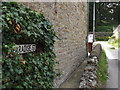
Paradise Street off Gisburn Road, Barrowford
Image: © Robert Wade
Taken: 29 Jun 2011
0.00 miles
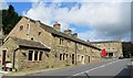
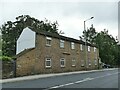
4
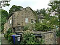
Fold, Gisburn Road, Higherford
Mid-18th century stone cottages, grade II listed (list entry 1073435).
Image: © Stephen Craven
Taken: 23 Aug 2022
0.02 miles
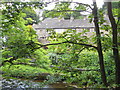
6
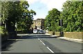
The A682 passes Higherford Mill
The A682 runs from Rawtenstall to Long Preston.
Image: © Steve Daniels
Taken: 28 Aug 2014
0.02 miles
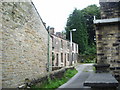
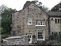
9
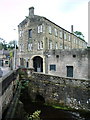
Higherford Mill, Barrowford
Featured in the BBC programme "Restoration 2006"
Image: © Alexander P Kapp
Taken: 23 Jul 2007
0.03 miles
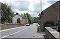
10
Former Methodist Sunday School, Higherford
Dated 1834, in residential use since 1972 (source: https://www.flickr.com/photos/rossendalewadey/5885068439 ). An early 20th century map shows a tram terminus outside; the tramway from Nelson opened in the early years of the century and closed in 1934.
Image: © Stephen Craven
Taken: 23 Aug 2022
0.03 miles