IMAGES TAKEN NEAR TO
Southfield Lane, COLNE, BB8 8HN
Introduction
This page details the photographs taken nearby to Southfield Lane, BB8 8HN by members of the Geograph project.
The Geograph project started in 2005 with the aim of publishing, organising and preserving representative images for every square kilometre of Great Britain, Ireland and the Isle of Man.

There are currently over 7.5m images from over14,400 individuals and you can help contribute to the project by visiting https://www.geograph.org.uk
Image Map
Images are licensed for reuse under creativecommons.org/licenses/by-sa/2.0
Notes
- Clicking on the map will re-center to the selected point.
- The higher the marker number, the further away the image location is from the centre of the postcode.
Image Listing (15 Images Found)
Images are licensed for reuse under creativecommons.org/licenses/by-sa/2.0
Image
Details
Distance
3
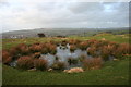
Castercliff Camp Hillfort
Bell pit on the top of the fort, these pits were filled in in 1515 prior to that it is recorded as early as 1296 that sea coals were won and sold within the Forest of Trawden, the Castercliff pits are thought to have provided coal to Bolton Abbey in 1328
Image: © Kevin Rushton
Taken: 2 Mar 2008
0.10 miles
4
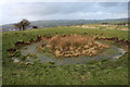
Castercliff Camp Hillfort
One of the many bell pit circles on top of the fort
Image: © Kevin Rushton
Taken: 2 Mar 2008
0.12 miles
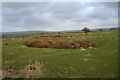
5
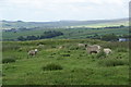
Sheep on Castercliff
This is the site of an Iron Age hill fort, and it does still have some discernible ramparts. The view beyond extends to Airedale.
Image: © Bill Boaden
Taken: 16 Jun 2011
0.13 miles
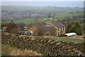
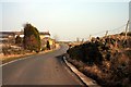
6
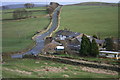
Southfield Lane
Looking from Castercliff Fort towards Gib Clough Head Farm and Black Lane
Image: © Kevin Rushton
Taken: 2 Mar 2008
0.13 miles
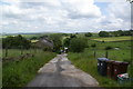
7
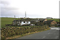
Southfield Lane
Delph Cottage, Gib Clough Head Farm House and Castercliff Barn
Image: © Kevin Rushton
Taken: 2 Mar 2008
0.14 miles
8
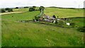
Gib Clough Head Farm
Viewed from Castercliff Hill Fort
Image: © Kevin Waterhouse
Taken: 9 Jun 2022
0.14 miles
9
Southfield Lane
Castercliff,Gib Clough Head Farm House and Delph Cottage. The road to the right is Back Lane
Image: © Kevin Rushton
Taken: 20 Feb 2008
0.14 miles
10
Castercliff Camp Hillfort
Castercliff is the county's best example of an Iron age hill fort it has hut circles and scars of bell pits on top, it has been dated back to the 6th century BC
Image: © Kevin Rushton
Taken: 2 Mar 2008
0.14 miles