IMAGES TAKEN NEAR TO
Hawthorne Place, CLITHEROE, BB7 2HU
Introduction
This page details the photographs taken nearby to Hawthorne Place, BB7 2HU by members of the Geograph project.
The Geograph project started in 2005 with the aim of publishing, organising and preserving representative images for every square kilometre of Great Britain, Ireland and the Isle of Man.

There are currently over 7.5m images from over14,400 individuals and you can help contribute to the project by visiting https://www.geograph.org.uk
Image Map
Images are licensed for reuse under creativecommons.org/licenses/by-sa/2.0
Notes
- Clicking on the map will re-center to the selected point.
- The higher the marker number, the further away the image location is from the centre of the postcode.
Image Listing (204 Images Found)
Images are licensed for reuse under creativecommons.org/licenses/by-sa/2.0
Image
Details
Distance
1
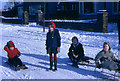
Children sledging in the street, 1969
A snowy scene in Hawthorne Place as children from several local families enjoy sledging.
The photo was taken by the submitter's father.
Image: © Frederick W Craven
Taken: Unknown
0.00 miles
2
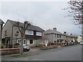
Hawthorne Place: middle phase of building
Hawthorne Place has three phases of building: older terraces nearest to Waddington Road, these mid-20th century semi-detached houses in the middle, and a more recent development of detached houses around the year 2000 on land at Hawthorne Farm at the far end Image
Image: © Stephen Craven
Taken: 9 Apr 2016
0.02 miles
3
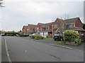
Hawthorne Place: latest phase of building
Hawthorne Place has three phases of building: older terraces nearest to Waddington Road, mid-20th century semi-detached houses in the middle Image, and this more recent development of detached houses around the year 2000 on land at Hawthorne Farm at the far end.
Image: © Stephen Craven
Taken: 9 Apr 2016
0.04 miles
4
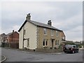
Former Hawthorne Farm, Clitheroe
This building at the north-east end of Hawthorne Place was a working farmhouse when I lived on the street in the 1960s. There used to be a set of barns to the west, seen in Image (the farmhouse being hidden in that view) but much of the farmland was sold to a developer around 2000 for building a housing estate.
Image: © Stephen Craven
Taken: 9 Apr 2016
0.05 miles
5
Former farm buildings, Hawthorne Place
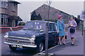
Apart from the 1960s fashions and vehicle (Ford Cortina), the geographical interest in this photo is the farm buildings behind, as they are no longer there (the site having been developed for housing). I recall playing in the farmyard as a child - it was a sheep rather than arable.
The photo was taken by the submitter's father.
Image: © Frederick W Craven
Taken: Unknown
0.05 miles
6

Playground on Hawthorne Place
A facility at the north-east end of the road, presumably provided as part of the planning conditions for the recent housing development Image although the swings and slide are more reminiscent of traditional playgrounds.
Image: © Stephen Craven
Taken: 9 Apr 2016
0.06 miles
7
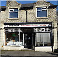
We Will Mend It
The sort of shop frontage that gives a man of a certain age the assurance before even setting foot inside that his vintage Roberts radio, non-digital version, will not only be repaired but restored to as good as new. But with those lovely old window frames why did they have to put that Expelair there?
Image: © Steve Reeves
Taken: 30 Oct 2010
0.07 miles
9
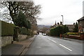
Watch your speed on Waddington Road, Clitheroe
The illuminated sign is frowning because someone has just driven past at 28mph in a 20mph zone. When drivers do 20mph or less, they get a smiley face.
Image: © Christine Johnstone
Taken: 12 Mar 2013
0.09 miles
10

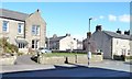
Eastham Street, Clitheroe
Showing position of Postbox No. BB7 415.
See Image] for postbox.
Image: © JThomas
Taken: 1 Oct 2016
0.10 miles