IMAGES TAKEN NEAR TO
Kings Highway, ACCRINGTON, BB5 5UX
Introduction
This page details the photographs taken nearby to Kings Highway, BB5 5UX by members of the Geograph project.
The Geograph project started in 2005 with the aim of publishing, organising and preserving representative images for every square kilometre of Great Britain, Ireland and the Isle of Man.

There are currently over 7.5m images from over14,400 individuals and you can help contribute to the project by visiting https://www.geograph.org.uk
Image Map
Images are licensed for reuse under creativecommons.org/licenses/by-sa/2.0
Notes
- Clicking on the map will re-center to the selected point.
- The higher the marker number, the further away the image location is from the centre of the postcode.
Image Listing (8 Images Found)
Images are licensed for reuse under creativecommons.org/licenses/by-sa/2.0
Image
Details
Distance
1
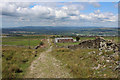
King's Highway descending towards Huncoat
Splendid views northwards on offer as far the Bowland Fells.
Image: © Chris Heaton
Taken: 5 Sep 2018
0.14 miles
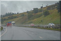
3
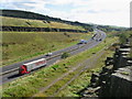
A56 Trunk Road
Looking south the A56 passes through the deep cutting at Moleside Moor
This is the link road between the M65 and M66.
Image: © Paul Anderson
Taken: 4 Oct 2007
0.18 miles
4
A56 Accington Easterly By-pass
Taken from the top of the cutting, looking SW towards Peel Park
Image: © Alexander P Kapp
Taken: 3 Feb 2006
0.20 miles
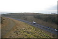
5
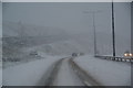
Snow on the Accrington bypass
This is just about to go through the cutting by Peel Park.
Image: © Bill Boaden
Taken: 2 Jan 2010
0.21 miles
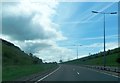
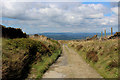
7
Accrington : The A56
Heading along the A56.
Image: © Lewis Clarke
Taken: 27 Sep 2019
0.24 miles
8
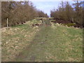
Peel Park
Peel Park is a large and varied site situated close to Accrington town centre that is approximately 88 hectares in size. It occupies land between Burnley Road (the A679), the A56 and Plantation Road and includes The Coppice area. The site contains many features and habitats of interest including open moorland, reservoirs, deep valleys and the remains of several quarries and landfill sites.
Peel Park also has an extensive footpath/bridleway network but this is in need of improvement and although popular with local residents the site has the potential to be used more widely by people throughout East Lancashire and beyond.
Image: © Robert Wade
Taken: 11 Mar 2009
0.24 miles