IMAGES TAKEN NEAR TO
Burnley Road, ACCRINGTON, BB5 5UG
Introduction
This page details the photographs taken nearby to Burnley Road, BB5 5UG by members of the Geograph project.
The Geograph project started in 2005 with the aim of publishing, organising and preserving representative images for every square kilometre of Great Britain, Ireland and the Isle of Man.

There are currently over 7.5m images from over14,400 individuals and you can help contribute to the project by visiting https://www.geograph.org.uk
Image Map
Images are licensed for reuse under creativecommons.org/licenses/by-sa/2.0
Notes
- Clicking on the map will re-center to the selected point.
- The higher the marker number, the further away the image location is from the centre of the postcode.
Image Listing (12 Images Found)
Images are licensed for reuse under creativecommons.org/licenses/by-sa/2.0
Image
Details
Distance
1
Footpath Junction Lower Moor Side Farm
The Junction of the footpath where it meets the track leading from the A678, from here it is possible to walk forwards to Syke Side or Brownsills farms, the track can be very wet after any rainfall.
Image: © Steve Houldsworth
Taken: 21 Sep 2011
0.01 miles
2
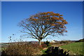
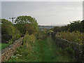
Autumn tree near Lower Moor Side
The path runs nearly parallel to Burnley Road linking up the local farms. Lower Moor Side is visible ahead. The path is very soft after recent rain.
Image: © Bill Boaden
Taken: 10 Nov 2013
0.06 miles
3
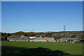
Farm above Wind Engine Clough
This farm has the name Farm House on the map, but there were no signs locally to confirm what it is called. You cannot escape seeing pylons in the Calder valley.
Image: © Bill Boaden
Taken: 10 Nov 2013
0.16 miles
4
Track to Lower Moor Side Farm Altham
The junction with the track and footpath to Lower Moor Side farm where it meets the A678 at Altham, the A678 is just out of the picture on the right.
Image: © Steve Houldsworth
Taken: 21 Sep 2011
0.17 miles
5
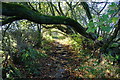
Path near Red House Farm
There is a stream running down the middle of the path, and you have to keep ducking under the overhanging branches.
Image: © Bill Boaden
Taken: 10 Nov 2013
0.17 miles
8
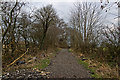
The track to Lower Moor Side
Complete with its quota of fly tipping
Image: © Ian Greig
Taken: 26 Feb 2016
0.22 miles
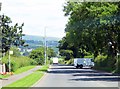
9
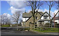
Martholme Grange, Burnley Road, Altham
This used to be a night club owned by Fred Skinner but is now a private home again
Image: © Robert Wade
Taken: 11 Mar 2009
0.22 miles
10
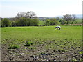
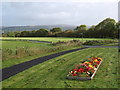
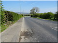
Grazing near Allotment Hall Farm
Off Burnley Road (A678).
Image: © JThomas
Taken: 19 Apr 2019
0.22 miles