IMAGES TAKEN NEAR TO
Balderstone Hall Lane, BLACKBURN, BB2 7LA
Introduction
This page details the photographs taken nearby to Balderstone Hall Lane, BB2 7LA by members of the Geograph project.
The Geograph project started in 2005 with the aim of publishing, organising and preserving representative images for every square kilometre of Great Britain, Ireland and the Isle of Man.

There are currently over 7.5m images from over14,400 individuals and you can help contribute to the project by visiting https://www.geograph.org.uk
Image Map
Images are licensed for reuse under creativecommons.org/licenses/by-sa/2.0
Notes
- Clicking on the map will re-center to the selected point.
- The higher the marker number, the further away the image location is from the centre of the postcode.
Image Listing (10 Images Found)
Images are licensed for reuse under creativecommons.org/licenses/by-sa/2.0
Image
Details
Distance
1
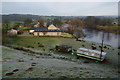
Balderstone Hall Farm
Situated next to the Ribble. It is more a country house now than a farm.
Image: © Bill Boaden
Taken: 28 Jan 2012
0.02 miles
2
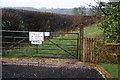
The end of public access at Balderstone Hall
The signs make it quite clear that the public path ends here. You have to turn round and go back the way you came. It is worth coming however as access to the south side of the Ribble is very limited.
Image: © Bill Boaden
Taken: 28 Jan 2012
0.08 miles
3
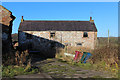
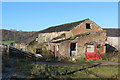
Sheep Fold Farm (1)
The farmhouse is deserted and abandoned - slowly falling into disrepair.
I believe planning permission is being sought for conversions.
Image: © Chris Heaton
Taken: 29 Nov 2019
0.09 miles
4
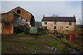
Disused farm near Balderstone Hall
The surrounding land is still in use and has been swallowed either by Balderstone Hall Farm or Lower House Farm.
Image: © Bill Boaden
Taken: 28 Jan 2012
0.10 miles
5
Sheep Fold Farm (2)
Outbuilding at the abandoned Sheep Fold Farm, falling into disrepair.
I believe planning permission is being sought for a conversion.
Image: © Chris Heaton
Taken: 29 Nov 2019
0.11 miles
6
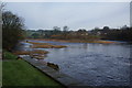
The River Ribble at Balderstone Hall
There is a small island in the river ahead.
Image: © Bill Boaden
Taken: 28 Jan 2012
0.12 miles
7
Boot Farm
Seen from the other side of the Ribble at Balderstone Hall Farm.
Image: © Bill Boaden
Taken: 28 Jan 2012
0.14 miles
8
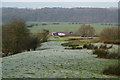
Path to Balderstone Hall
The path isn't very visible but the walking is easy. The farm at the bottom is now disused. It is the Ribble Valley beyond, but the river is not obvious.
Image: © Bill Boaden
Taken: 28 Jan 2012
0.14 miles
9
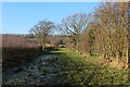
Wide Grass Footpath by Sheep Fold Farm
Section of the public footpath between Lower House Farm and Balderstone Hall
Image: © Chris Heaton
Taken: 29 Nov 2019
0.15 miles
10
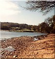
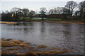
Alston Island
An island in the River Ribble.
Image: © Gerald England
Taken: 3 May 1980
0.16 miles