IMAGES TAKEN NEAR TO
Laurel Bank Terrace, BLACKBURN, BB2 5JA
Introduction
This page details the photographs taken nearby to Laurel Bank Terrace, BB2 5JA by members of the Geograph project.
The Geograph project started in 2005 with the aim of publishing, organising and preserving representative images for every square kilometre of Great Britain, Ireland and the Isle of Man.

There are currently over 7.5m images from over14,400 individuals and you can help contribute to the project by visiting https://www.geograph.org.uk
Image Map
Images are licensed for reuse under creativecommons.org/licenses/by-sa/2.0
Notes
- Clicking on the map will re-center to the selected point.
- The higher the marker number, the further away the image location is from the centre of the postcode.
Image Listing (21 Images Found)
Images are licensed for reuse under creativecommons.org/licenses/by-sa/2.0
Image
Details
Distance
1
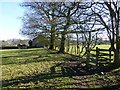
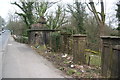
Terraced houses at Feniscowles
Looking down from the drive to Hillock Farm. This is the beginning of the Blackburn conurbation from the south west. Through the trees is the chimney of the paper mill, now disused.
Image: © Bill Boaden
Taken: 15 Mar 2012
0.01 miles
2
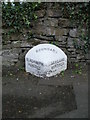
Old Boundary Marker by Moulden Brow, Feniscowles, Withnell Parish
Parish Boundary Marker by the A674, in parish of Withnell (Chorley District), Moulden Brow, Feniscowles, opposite No. 27, on pavement against stone wall. On the former boundary of Hoghton and Livesey townships, both parishes from 1866. Now entirely in Withnell parish. See also https://www.geograph.org.uk/photo/7746339.
Inscription reads:-
: BLACKBURN / HUNDRED / LIVESEY : : BOUNDARY : : LEYLAND / HUNDRED / HOGHTON :
Surveyed
Milestone Society National ID: LA_HOGLIV01pb
Image: © Philip Platt
Taken: 15 Feb 2012
0.02 miles
3

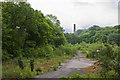
The Witton Weavers Way approaching the A674
The long distance footpath crosses the Leeds and Liverpool Canal, before descending into an area of waste ground that takes the route onto the A674 in Feniscowles.
Image: © Chris Heaton
Taken: 17 Jul 2021
0.05 miles
4
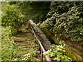
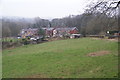
Mill Race
This mill race leads from a reservoir/lodge at Stanworth to the River Roddlesworth at the site of the former Sun and Star paper mills. It was probably built at the same time as the mills (1874 and 1875 respectively) and would have served either or both of them.
Image: © David Dixon
Taken: 29 Jul 2012
0.06 miles
5
The old entrance to the Old and New Halls
The drive which once started here provided access to Feniscowles New and Old Halls.
Image: © Bill Boaden
Taken: 15 Mar 2012
0.08 miles

7
The Witton Weavers Way
The paper mill beyond the trees is currently being demolished (noisily)
Image: © Ian Greig
Taken: 1 Jun 2012
0.09 miles
8
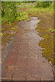
Nature takes over
These tiles would have been part of a floor in the now demolished Sun paper mill.
Image: © Mr T
Taken: 30 Jun 2007
0.10 miles
9
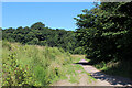
The Witton Weavers Way crosses Waste Ground near Feniscowles
Image: © Chris Heaton
Taken: 17 Jul 2021
0.14 miles