IMAGES TAKEN NEAR TO
St. James Square, BARNOLDSWICK, BB18 5NU
Introduction
This page details the photographs taken nearby to St. James Square, BB18 5NU by members of the Geograph project.
The Geograph project started in 2005 with the aim of publishing, organising and preserving representative images for every square kilometre of Great Britain, Ireland and the Isle of Man.

There are currently over 7.5m images from over14,400 individuals and you can help contribute to the project by visiting https://www.geograph.org.uk
Image Map
Images are licensed for reuse under creativecommons.org/licenses/by-sa/2.0
Notes
- Clicking on the map will re-center to the selected point.
- The higher the marker number, the further away the image location is from the centre of the postcode.
Image Listing (466 Images Found)
Images are licensed for reuse under creativecommons.org/licenses/by-sa/2.0
Image
Details
Distance
1
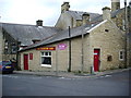
The Salvation Army, St James' Road, Barnoldswick
Image: © Alexander P Kapp
Taken: 27 Aug 2007
0.00 miles
3
The 'Railway' public house, Barnoldswick, Yorkshire
It is a shame that the owners have seen fit to degrade this solid pub with modernistic signs - the pub. sign is just a stylised 'r'. Much better to have a sign depicting a Midland Railway tank engine such as would have been seen regularly on the Barnoldswick branch in its heyday, even though there have been no trains in Barnoldswick now for nearly forty years.
Image: © Dr Neil Clifton
Taken: 7 Jul 2007
0.01 miles
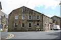
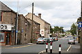
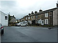
4
The beginning of Skipton Road, Barnoldswick, Yorkshire
As seen from the end of Newtown. The bank seen on the left is actually No 1 Skipton Road, and No 2 is the house (on the other side) just beyond Cairo's. Cairo's itself is No 1 Station Road. On the right are seen the Yorkshire Bank and then the 'Railway' public house.
Image: © Dr Neil Clifton
Taken: 7 Jul 2007
0.01 miles
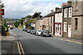
5
Station Road, Barnoldswick, Yorkshire
A short one-way street leading from the end of Church Street and Skipton Road, to Fern Lea Avenue. Beyond Fern Lea Avenue is Wellhouse Road.
Image: © Dr Neil Clifton
Taken: 7 Jul 2007
0.01 miles
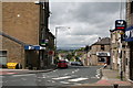
6
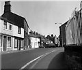
Skipton Road, (south end), Barnoldswick, Yorkshire
This shows the extreme south end of Skipton Road, looking northwards away from the Town Centre. The shops on the right are stone roofed and very old. On the left rises St. James' Road (not to be confused with St James' Square), only recently surfaced. Further down on the left is Barnoldswick Church, but not visible here.
Image: © Dr Neil Clifton
Taken: 7 Jul 2007
0.01 miles
8
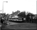
Station Road, Barnoldswick
This is the main picking-up point for buses to Colne and Burnley. Here a Leyland National on Route X28 for Burnley is about to leave, while its competitor, one of Tyrer's vehicles which will follow the same route, is just behind.
Image: © Dr Neil Clifton
Taken: 29 Dec 1988
0.01 miles
10
Church Street, Barnoldswick
Looking north-east along the street, the railings on the right belong to the small car park in front of the 'Cross Keys' pub. In the distance with a pseudo-Dutch gable, is another pub, the 'Barlick'. [Note for strangers to Barnoldswick: natives of the town as commonly referred to as 'Barlickers': others as 'Comed off uns'.]
Image: © Dr Neil Clifton
Taken: 3 Aug 1982
0.02 miles