IMAGES TAKEN NEAR TO
Stalbridge Road, TEMPLECOMBE, BA8 0SA
Introduction
This page details the photographs taken nearby to Stalbridge Road, BA8 0SA by members of the Geograph project.
The Geograph project started in 2005 with the aim of publishing, organising and preserving representative images for every square kilometre of Great Britain, Ireland and the Isle of Man.

There are currently over 7.5m images from over14,400 individuals and you can help contribute to the project by visiting https://www.geograph.org.uk
Image Map (Loading...)


Getting Data...Please wait
Leaflet Map data © OpenStreetMap
Images are licensed for reuse under creativecommons.org/licenses/by-sa/2.0
Notes
- Clicking on the map will re-center to the selected point.
- The higher the marker number, the further away the image location is from the centre of the postcode.
Image Listing (19 Images Found)
Images are licensed for reuse under creativecommons.org/licenses/by-sa/2.0
Image
Details
Distance
1
Boundary Post, Henstridge
Dorset to the south, Somerset to the north.
Image: © Becky Williamson
Taken: 30 Aug 2018
0.12 miles
2
Dorset/Somerset border south of Henstridge
Image: © Becky Williamson
Taken: 30 Aug 2018
0.12 miles
3
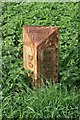
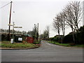
County Boundary Post near Stalbridge
On the A357 at the junction with Landshire Lane stands this boundary post. Cast-iron, V-shaped at the base, bevelled top dated 1909; DORSET vertically to the left, and SOMERSET vertically to the right. One of a number probably erected by Somerset. Note also the well-maintained SCC finger post.
Image: © Mike Faherty
Taken: 8 Sep 2007
0.12 miles
4

Old Boundary Marker by the A357, Stalbridge Road, Henstridge
County Boundary Marker by the A357, in parish of Henstridge (South Somerset District), on crossroads junction with Landshire Lane, South West corner by SCC fingerpost: SO_ST7219 Image
Inscription reads:- : DORSET : : BOUNDARY / 1909 : : SOMERSET :
Surveyed
Milestone Society National ID: SO_SSDO02cb
Image: © Milestone Society
Taken: Unknown
0.12 miles

6
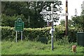
Old Direction Sign - Signpost by the A357, Henstridge parish
Pyramid finial - 4 arms; Somerset SCC pyramid by the A357, in parish of Henstridge (South Somerset District), near Newhouse Farm, junction with Landshire Lane at county boundary, on verge.
Surveyed
Milestone Society National ID: SO_ST7219
Image: © Milestone Society
Taken: Unknown
0.12 miles
7

Boundary post, Henstridge
The Dorset/Somerset boundary post is dated 1909. For a wider view http://www.geograph.org.uk/photo/2043805
Image: © Maigheach-gheal
Taken: 30 Aug 2010
0.12 miles
8
County boundary, Henstridge
Beside the finger post at the junction of the A357 and Landshire Lane is a cast iron boundary post. The finger post itself has a crude correction on it.
Image: © Maigheach-gheal
Taken: 30 Aug 2010
0.13 miles
9
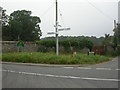
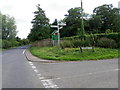
Cross Roads on the A357
The road in the foreground is the A357 just south of Henstridge and the road running away is the minor road to Frith House. It also marks the northern Park Wall of Stalbridge House.
Image: © Nigel Mykura
Taken: 26 Jan 2017
0.14 miles
10
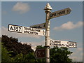
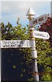
Henstridge: close-up of erroneous old sign
A closer look at Image, showing that the Stalbridge and Bournemouth finger was embossed with the road number A359, altered rather crudely to the correct A357 in the paintwork.
Since the opposite finger is correctly embossed, I am assuming this is a genuine mistake rather than the result of reclassification.
Image: © Chris Downer
Taken: 13 Jun 2010
0.14 miles