IMAGES TAKEN NEAR TO
The Mead, Southmead Lane, TEMPLECOMBE, BA8 0RR
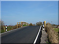
Introduction
This page details the photographs taken nearby to The Mead, Southmead Lane, BA8 0RR by members of the Geograph project.
The Geograph project started in 2005 with the aim of publishing, organising and preserving representative images for every square kilometre of Great Britain, Ireland and the Isle of Man.

There are currently over 7.5m images from over14,400 individuals and you can help contribute to the project by visiting https://www.geograph.org.uk
Image Map
Images are licensed for reuse under creativecommons.org/licenses/by-sa/2.0
Notes
- Clicking on the map will re-center to the selected point.
- The higher the marker number, the further away the image location is from the centre of the postcode.
Image Listing (14 Images Found)
Images are licensed for reuse under creativecommons.org/licenses/by-sa/2.0
Image
Details
Distance
1
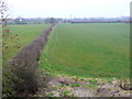
Trackbed of the Somerset and Dorset Railway
This is the line of the old now dismantled track of the S&D Railway, looking north into Somerset in the direction of Henstridge whose houses can just be seen on the far left. The photo was taken from the Landshire Lane Bridge.
Image: © Nigel Mykura
Taken: 20 Feb 2013
0.09 miles
2
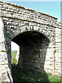
Bridge over the former S & D Railway (2)
Second photo and different viewpoint of this bridge over the former Somerset & Dorset Railway.
Image: © Mike Searle
Taken: 5 Apr 2007
0.19 miles
3
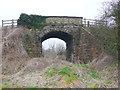
Old Railway Bridge
The track on this line which used to run from Templecombe to Sturminster Newton has long been dismantled but the bridge remains carrying Landshire lane over the former track bed. The lane gets its name from the fact that Dorset is on one side of the bridge and Somerset on the other
Image: © Nigel Mykura
Taken: 20 Feb 2013
0.19 miles
4
Footpath to Steel Well Lane
Leading from the High Street, Henstridge, and off to the east side of the village. There are a few springs to mark the well.
Image: © Neil Owen
Taken: 7 Jun 2023
0.20 miles
5
Bridge over the former S & D Railway Line
Arguably Britain's best loved railway, the former Somerset & Dorset Railway's mainline route ran from Bath through the Mendips, and on through Dorset, where it connected at Broadstone with the L&SWR route to Bournemouth. The course of the old line passes under this road bridge between Henstridge and Stalbridge.
Image: © Mike Searle
Taken: 5 Apr 2007
0.20 miles
6

Wildflowers on Woodhayes Way
Some colour at the back of a new house in Henstridge.
Image: © Neil Owen
Taken: 7 Jun 2023
0.22 miles

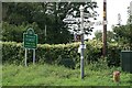
8
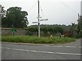
County Boundary Post near Stalbridge
On the A357 at the junction with Landshire Lane stands this boundary post. Cast-iron, V-shaped at the base, bevelled top dated 1909; DORSET vertically to the left, and SOMERSET vertically to the right. One of a number probably erected by Somerset. Note also the well-maintained SCC finger post.
Image: © Mike Faherty
Taken: 8 Sep 2007
0.24 miles
9
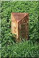
Boundary Post, Henstridge
Dorset to the south, Somerset to the north.
Image: © Becky Williamson
Taken: 30 Aug 2018
0.24 miles
10
Dorset/Somerset border south of Henstridge
Image: © Becky Williamson
Taken: 30 Aug 2018
0.24 miles