IMAGES TAKEN NEAR TO
South Cheriton, TEMPLECOMBE, BA8 0BS
Introduction
This page details the photographs taken nearby to BA8 0BS by members of the Geograph project.
The Geograph project started in 2005 with the aim of publishing, organising and preserving representative images for every square kilometre of Great Britain, Ireland and the Isle of Man.

There are currently over 7.5m images from over14,400 individuals and you can help contribute to the project by visiting https://www.geograph.org.uk
Image Map
Images are licensed for reuse under creativecommons.org/licenses/by-sa/2.0
Notes
- Clicking on the map will re-center to the selected point.
- The higher the marker number, the further away the image location is from the centre of the postcode.
Image Listing (19 Images Found)
Images are licensed for reuse under creativecommons.org/licenses/by-sa/2.0
Image
Details
Distance
1
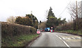
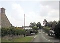
Road works on A357
By Meadow View south of South Cheriton
Image: © John Firth
Taken: 11 Apr 2013
0.08 miles
2
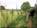
Monarch's Way near South Cheriton
Beyond the gate shown in Image], the Way follows footpath WN 14/4 along a track between Keepers Well and The Old Forge to meet the A357.
Image: © Derek Harper
Taken: 14 Sep 2013
0.10 miles
3
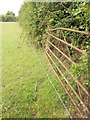
Electric fence on Monarch's Way
An awkward bit of the Way. A gate you have to climb is right beside an electric fence with no easy means of crossing.
Image: © Derek Harper
Taken: 14 Sep 2013
0.11 miles
4
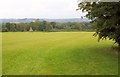
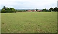
Monarch's Way near South Cheriton
With the A357 Higher Road a little behind the camera, the Way follows footpath WN 14/4 across a wide field to meet Lower Road. On the left is the Cemetery Chapel at South Cheriton.
Image: © Derek Harper
Taken: 14 Sep 2013
0.12 miles
6
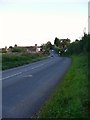
The A357 through South Cheriton looking south
Image: © Shazz
Taken: 27 Sep 2012
0.16 miles
7
Houses on the A357
Seen from the Monarch's Way crossing a pasture on footpath WN 14/4. The Way goes over a gate into the trees on the left, although the gate doesn't open and there's an electric fence in front of it.
Image: © Derek Harper
Taken: 14 Sep 2013
0.16 miles
8
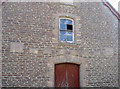
Initials on the hall
The Unsectarian Temperance Hall in South Cheriton was built during the Victorian Jubilee. The doors are perhaps modern but the many stone tablets in the wall have initials - presumably the important and worthy patrons in the village.
Image: © Neil Owen
Taken: 14 Sep 2016
0.17 miles
9
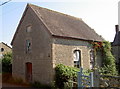
Unsectarian Temperance Hall
South Cheriton is a small village even these days, but in 1887 it opened a Temperance Hall - a venue where alcohol was strictly abstained, as was the movement in Victorian times. The Unsectarian aspect must have appealed to the various religious groups in the area.
Image: © Neil Owen
Taken: 14 Sep 2016
0.17 miles
10
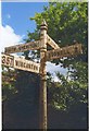
Direction Sign - Signpost on the A357 in South Cheriton
Pyramid finial - 4 arms; Somerset SCC pyramid by the A357, in parish of Horsington (South Somerset District), in South Cheriton on the southeast side of the staggered crossroads of the A357 Higher Road, Cabbage Lane and Cheriton Street.
surveyed
Milestone Society National ID: SO_ST6924
Image: © Milestone Society
Taken: Unknown
0.17 miles