IMAGES TAKEN NEAR TO
St. Andrews Street, WELLS, BA5 2UR
Introduction
This page details the photographs taken nearby to St. Andrews Street, BA5 2UR by members of the Geograph project.
The Geograph project started in 2005 with the aim of publishing, organising and preserving representative images for every square kilometre of Great Britain, Ireland and the Isle of Man.

There are currently over 7.5m images from over14,400 individuals and you can help contribute to the project by visiting https://www.geograph.org.uk
Image Map
Images are licensed for reuse under creativecommons.org/licenses/by-sa/2.0
Notes
- Clicking on the map will re-center to the selected point.
- The higher the marker number, the further away the image location is from the centre of the postcode.
Image Listing (1392 Images Found)
Images are licensed for reuse under creativecommons.org/licenses/by-sa/2.0
Image
Details
Distance
1
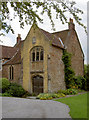
The Rib
An old house near the gate to Wells Cathedral, known as 'The Rib'. It is the only one remaining of five originals, a gift from the Bishop and used as a theological college. It contains many original features, the oldest possibly from the twelfth century, but has had recorded occupants dating from the fourteenth century. It is now in private hands.
Image: © Neil Owen
Taken: 27 Jul 2011
0.01 miles
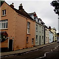
2
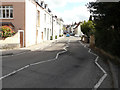
Looking east-northeast along St Thomas Street
Image: © John Baker
Taken: 2 Apr 2016
0.01 miles
3
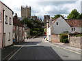
St. Thomas Street, Wells, Somerset (2013)
Taken 58 years after the photographer last stood on this spot. See Image
The magnificent Cathedral stands in the background.
Image: © Derek Voller
Taken: 14 Sep 2013
0.01 miles
4
St Andrew Street, Wells
The Fountain Inn http://www.geograph.org.uk/photo/5283063 is in the background.
Image: © Jaggery
Taken: 27 Sep 2016
0.01 miles
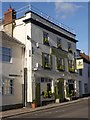
5
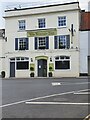
The Fountain Inn, Wells
The Fountain Inn located on Tor Road, Wells. The building also has an Ordnance Survey bench mark.
Image
Image: © V1ncenze
Taken: 6 Aug 2021
0.01 miles
6
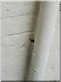
Ordnance Survey Bench Mark
This mark is located on the Fountain Inn, Tor road, Wells. These marks were used by Ordnance Survey for mapping purposes. The mark has, over time, been filled in with paint and is rather obscure.
Image
Image: © V1ncenze
Taken: 6 Aug 2021
0.01 miles
7
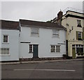
From St Andrew Street to St Thomas Street, Wells
Two different street names are on the house facing Tor Street.
The name sign on the left showing ST ANDREWS STREET appears to be wrong
because the local council references to this street show St Andrew Street.
The Fountain Inn http://www.geograph.org.uk/photo/5283063 is on the right.
Image: © Jaggery
Taken: 27 Sep 2016
0.02 miles
8

The possible remains of a cut bench mark on the Fountain Inn
Possibly just the datum cut of a bench mark, no arrow cuts, on the south-west face, south angle of the Fountain Inn. See http://www.geograph.org.uk/photo/5572820 for a wider view and http://www.bench-marks.org.uk/bm89778 for details of the bench mark.
Image: © Brian Westlake
Taken: 8 Oct 2017
0.02 miles
9
The Fountain Inn, Wells
The nearest angle, left face, carries a mark which is possibly the datum cut only of the benchmark described at http://www.bench-marks.org.uk/bm89778. See http://www.geograph.org.uk/photo/5572816 for a close-up.
Image: © Brian Westlake
Taken: 8 Oct 2017
0.02 miles