IMAGES TAKEN NEAR TO
The Liberty, WELLS, BA5 2SU
Introduction
This page details the photographs taken nearby to The Liberty, BA5 2SU by members of the Geograph project.
The Geograph project started in 2005 with the aim of publishing, organising and preserving representative images for every square kilometre of Great Britain, Ireland and the Isle of Man.

There are currently over 7.5m images from over14,400 individuals and you can help contribute to the project by visiting https://www.geograph.org.uk
Image Map
Images are licensed for reuse under creativecommons.org/licenses/by-sa/2.0
Notes
- Clicking on the map will re-center to the selected point.
- The higher the marker number, the further away the image location is from the centre of the postcode.
Image Listing (1441 Images Found)
Images are licensed for reuse under creativecommons.org/licenses/by-sa/2.0
Image
Details
Distance
1
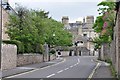
Wells : The B3139
The B3139 heading through Wells and up to Wells School.
Image: © Lewis Clarke
Taken: 15 Jun 2012
0.02 miles
2
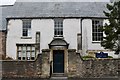
Polydor House, Wells
Grade II* listed. Listing number 1383163. Large detached house, formerly known as The Organist's House. C15 fragments, with C16, C17, C18 and C19 additions and alterations.
Image: © Andrew Abbott
Taken: 20 Sep 2015
0.03 miles
3

The Vicars' Close
The Vicars' Close dates from 1348 and is considered to be the oldest surviving, and still inhabited, terrace of houses in the country. The vicars of the cathedral were organised on a collegiate basis and provided with their own accommodation within the bounds of the cathedral itself.
Image: © Patrick Mackie
Taken: 10 Oct 2004
0.03 miles
4
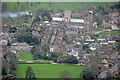
Aerial View of Wells Cathedral
An aerial view that takes in Wells Cathedral School, Vicars Close and the Cathedral
Image: © Pete Penfold
Taken: 15 Jan 2006
0.03 miles
5
![Wells houses [9]](https://s0.geograph.org.uk/geophotos/06/28/33/6283304_963b24b1_120x120.jpg)
Wells houses [9]
Number 18 Vicars Close.
Vicars Close is a double row of houses enclosing a street of about 140 metres. There were originally 44 houses, now 27, with some units combined into a single dwelling. Built circa 1360 for the Vicars Choral there have been various rear extensions in the 16th, 17th and 18th centuries with refenestration in the 18th and early 19th centuries. The properties were extensively restored between 1976 and 1983.
Numbers 14 to 27 are listed, grade I, with details at: https://historicengland.org.uk/listing/the-list/list-entry/1383199
The boundary walls to these houses are listed, grade I, with details at: https://historicengland.org.uk/listing/the-list/list-entry/1383200
A Roman settlement around three wells that became much more important when the Anglo-Saxon King Ine of Wessex founded a minster church in 704, Wells is the second smallest city in England.
Image: © Michael Dibb
Taken: 23 Aug 2019
0.04 miles
6
Wells : Shrewsbury House
The sole building in Vicars Close, Wells, Somerset, that does not date from the mid 14th century, Shrewsbury House was rebuilt in the 19th century after a fire.
Image: © Lewis Clarke
Taken: 22 Jul 2015
0.04 miles
7
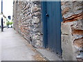
Free benchmark
A cutmark, as listed in the Benchmark Database: http://www.bench-marks.org.uk/bm50821 , by a door on The Liberty. See Image] for a wider view.
Image: © Neil Owen
Taken: 4 Jul 2013
0.04 miles
8
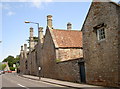
Closed off to traffic
This is the northern end of Vicars Close, as seen from The Liberty. The close is regarded as the oldest preserved example of a purely residential street. A benchmark can be found by the blue door - Image
Image: © Neil Owen
Taken: 4 Jul 2013
0.04 miles
9
![Wells houses [8]](https://s3.geograph.org.uk/geophotos/06/28/33/6283303_2b961dd5_120x120.jpg)
Wells houses [8]
Number 16 Vicar's Close. This wide 5-bay property, incorporating two original properties, appears to have been almost completely rebuilt in the late 18th century.
Vicar's Close is a double row of houses enclosing a street of about 140 metres. There were originally 44 houses, now 27, with some units combined into a single dwelling. Built circa 1360 for the Vicars Choral there have been various rear extensions in the 16th, 17th and 18th centuries with refenestration in the 18th and early 19th centuries. The properties were extensively restored between 1976 and 1983.
Numbers 14 to 27 are listed, grade I, with details at: https://historicengland.org.uk/listing/the-list/list-entry/1383199
The boundary walls to these houses are listed, grade I, with details at: https://historicengland.org.uk/listing/the-list/list-entry/1383200
A Roman settlement around three wells that became much more important when the Anglo-Saxon King Ine of Wessex founded a minster church in 704, Wells is the second smallest city in England.
Image: © Michael Dibb
Taken: 23 Aug 2019
0.04 miles
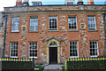
10
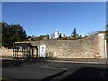
Bus shelter in The Liberty, Wells
Over the wall is the lantern of Lantern House
Image: © David Smith
Taken: 17 Nov 2017
0.04 miles