IMAGES TAKEN NEAR TO
New Street, WELLS, BA5 2LE
Introduction
This page details the photographs taken nearby to New Street, BA5 2LE by members of the Geograph project.
The Geograph project started in 2005 with the aim of publishing, organising and preserving representative images for every square kilometre of Great Britain, Ireland and the Isle of Man.

There are currently over 7.5m images from over14,400 individuals and you can help contribute to the project by visiting https://www.geograph.org.uk
Image Map (Loading...)


Getting Data...Please wait
Leaflet Map data © OpenStreetMap
Images are licensed for reuse under creativecommons.org/licenses/by-sa/2.0
Notes
- Clicking on the map will re-center to the selected point.
- The higher the marker number, the further away the image location is from the centre of the postcode.
Image Listing (295 Images Found)
Images are licensed for reuse under creativecommons.org/licenses/by-sa/2.0
Image
Details
Distance
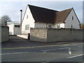
2
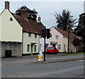
Three Grade II listed houses, New Street, Wells
Numbers 21, 23 and 25 New Street are Grade II listed.
Image: © Jaggery
Taken: 27 Sep 2016
0.02 miles
4
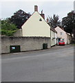
Mountery Road telecoms cabinets, Wells
The dark green cabinets are alongside a wall on the north
side of the A39 Mountery Road near the New Street junction.
Image: © Jaggery
Taken: 27 Sep 2016
0.05 miles
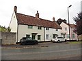
5
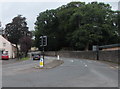
A39 New Street, Wells
On the north side of the junction of the A39 Mountery Road and the B3139 New Street.
Image: © Jaggery
Taken: 27 Sep 2016
0.05 miles
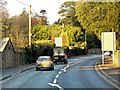
6
Wells Cathedral School Woodlands Workshop, Wells
In late September 2016, temporary fencing surrounds the southern edge of Woodlands Workshop.
Image: © Jaggery
Taken: 27 Sep 2016
0.06 miles
7
Queueing at traffic lights, Mountery Road, Wells
The cars on the A39 Mountery Road are stopped at the New Street junction.
Image: © Jaggery
Taken: 27 Sep 2016
0.07 miles
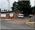
8
Building site
Seen from New Street (A39), the development is described in Mendip District Council’s planning application 2012/1472 as the “construction of 62 one and two storey dwellings including 35 sheltered housing units together with associated highways, car parking, landscaping and open space”. The site has been named Ash Rise and is accessed from Ash Close. David Dixon’s Image shows this road near to its junction with Ash Lane.
Image: © John Baker
Taken: 2 Apr 2016
0.08 miles
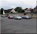
9
Wells Telephone Exchange (1)
Situated on the A39 Mountery Road, this TE serves the city of Wells plus Bleadney, Burcott, Chilcote, Coxley, Dinder, Dulcote, East Horrington, Haybridge, Haydon, Henton, Polsham, West Horrington, Wookey, Wookey Hole and Yarley nearby. It has (01749) 67xxxx, 68xxxx numbers and its postcode is BA5 2QN.
Image: © David Hillas
Taken: 14 Apr 2011
0.09 miles
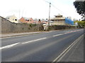
10
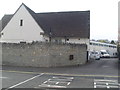
Wells Telephone Exchange (2)
Situated on the A39 Mountery Road, this TE comprises of the original building dating from the GPO era on the left, whilst the later extension can be seen in the background on the right.
Image: © David Hillas
Taken: 14 Apr 2011
0.09 miles