IMAGES TAKEN NEAR TO
Charter Way, WELLS, BA5 2GJ
Introduction
This page details the photographs taken nearby to Charter Way, BA5 2GJ by members of the Geograph project.
The Geograph project started in 2005 with the aim of publishing, organising and preserving representative images for every square kilometre of Great Britain, Ireland and the Isle of Man.

There are currently over 7.5m images from over14,400 individuals and you can help contribute to the project by visiting https://www.geograph.org.uk
Image Map
Images are licensed for reuse under creativecommons.org/licenses/by-sa/2.0
Notes
- Clicking on the map will re-center to the selected point.
- The higher the marker number, the further away the image location is from the centre of the postcode.
Image Listing (17 Images Found)
Images are licensed for reuse under creativecommons.org/licenses/by-sa/2.0
Image
Details
Distance
1

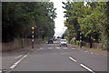
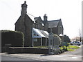
Wheeler Grove, Wells
Suburban street on the western edge of the city.
Image: © Des Blenkinsopp
Taken: 29 Aug 2014
0.02 miles
3
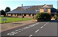
Wells Leisure Centre
Sports, Swimming, Fitness, Exercise, all that stuff, plus a cafe, hopefully with big slices of cake.
Image: © Des Blenkinsopp
Taken: 23 Aug 2014
0.13 miles
4
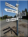
Direction Sign - Signpost on the A371 at Haybridge
Located in Haybridge in the centre of the Y junction of the A371 and the B3139 Elm Close. Wells parish. 4 arms and pyramid finial. The Weston arm was lost some time before July 2011 but has now been replaced. See https://www.geograph.org.uk/photo/6056199 for an older photo.
Milestone Society National ID: SO_ST5345
Image: © Roadside Relics
Taken: 29 Jul 2024
0.13 miles
5
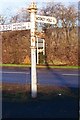
Direction Sign - Signpost on the A371 at Haybridge
Pyramid finial - 4 arms, 1 missing; Somerset SCC pyramid by the A371, in parish of Wells (Mendip District), in Haybridge in the centre of the Y junction of the A371 and the B3139 Elm Close.
surveyed
Milestone Society National ID: SO_ST5345
Image: © Milestone Society
Taken: Unknown
0.13 miles

8
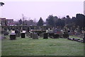
Wells Cemetery
On the western side of the city. The tower of St Cuthbert's Church is just visible.
Image: © Bill Boaden
Taken: 30 Dec 2016
0.14 miles
9
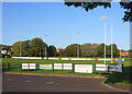
Adverts by the Rugby Field
A scene at Wells Rugby Club.
Image: © Des Blenkinsopp
Taken: 23 Aug 2014
0.15 miles
10
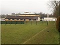
Wells Leisure Centre
Built on a recreation ground, the centre has a swimming pool, sports hall, spa, fitness centre, plus cafe, creche and meeting rooms.
Image: © Derek Harper
Taken: 22 Feb 2010
0.16 miles