IMAGES TAKEN NEAR TO
Top Road, WELLS, BA5 1JB
Introduction
This page details the photographs taken nearby to Top Road, BA5 1JB by members of the Geograph project.
The Geograph project started in 2005 with the aim of publishing, organising and preserving representative images for every square kilometre of Great Britain, Ireland and the Isle of Man.

There are currently over 7.5m images from over14,400 individuals and you can help contribute to the project by visiting https://www.geograph.org.uk
Image Map
Images are licensed for reuse under creativecommons.org/licenses/by-sa/2.0
Notes
- Clicking on the map will re-center to the selected point.
- The higher the marker number, the further away the image location is from the centre of the postcode.
Image Listing (81 Images Found)
Images are licensed for reuse under creativecommons.org/licenses/by-sa/2.0
Image
Details
Distance
1
Former Telephone Exchange, Westbury-sub-Mendip
Situated on the A371 Wells Road, this TE dates from the GPO era and used to take the name Priddy, a village on the Mendip Hills a few miles northeast of Westbury-sub-Mendip. It was replaced somewhile ago by a modern TE in Top Road, ST 5048 refers http://www.geograph.org.uk/photo/2657597. The postcode of this former TE is BA5 1EX.
Image: © David Hillas
Taken: 14 Apr 2011
0.06 miles
2
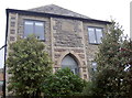
The old chapel
This Bible Christian Chapel was founded in 1872, according to the rather damaged date stone. Today it is a private residence.
Image: © Neil Owen
Taken: 27 Oct 2016
0.07 miles
3
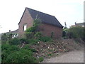
Perch Lane
Some inclusive construction regarding Perch Hill Cottage: what appears to be a natural outcrop of Mendip limestone has been made a feature of the foundations.
Image: © Neil Owen
Taken: 27 Oct 2016
0.08 miles
4
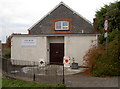
New Telephone Exchange, Westbury-sub-Mendip
Situated in Top Road, this modern TE replaced the former TE in Wells Road somewhile ago, ST 5048 refers http://www.geograph.org.uk/photo/2657578. Besides Westbury-sub-Mendip, this TE also serves Easton, Priddy and Rodney Stoke nearby. This TE has (01749) 870xxx numbers whilst its postcode is BA5 1HY.
Image: © David Hillas
Taken: 14 Apr 2011
0.11 miles
5
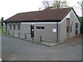
Westbury-sub-Mendip village hall
The villagers had hoped to be able to use the recently built schoolrooms as a public venue but were denied; they subsequently embarked on a strenuous fund-raising effort to secure a suitable community resource. The village hall was built by local builders the Dennis brothers in just three months. The cost of the land and the building was around £350 and these funds were raised by the villagers over a period of time. It was officially opened on Wednesday, 10th December 1913 by Mrs Graves-Knyfton of Uphill Manor. The local church bells rang in celebration.
Perhaps there is a bridge afternoon in progress today. Or possibly the weekly poker tournament?
Image: © Neil Owen
Taken: 27 Oct 2016
0.11 miles
6
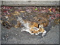
Ruined Reynard
An unfortunate sight on the A371: one fox has met its maker, along with what looks like many other wheels afterwards. The pitiful sight of a little black nose and an ear mark it out.
Image: © Neil Owen
Taken: 27 Oct 2016
0.11 miles
7

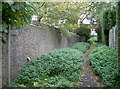
Footpath, Westbury-Sub-Mendip
Footpath WS 13/16 from Crow Lane reaches a stone stile onto the lane east of The Square.
Image: © Derek Harper
Taken: 22 May 2010
0.12 miles
8
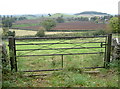
Gateway to the foothills
A simple field gate has a broad panorama of the Somerset Levels and the Mendip's scattered hills.
Image: © Neil Owen
Taken: 27 Oct 2016
0.12 miles
9
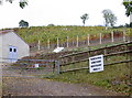
Perch Hill Vineyard
Established in 2012 it appears.
Image: © Neil Owen
Taken: 27 Oct 2016
0.12 miles
10
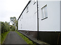
Crow Lane
The road shrinks to a leafy path beside the stream here and becomes a public footpath.
Image: © Neil Owen
Taken: 27 Oct 2016
0.12 miles