IMAGES TAKEN NEAR TO
Underwood Business Park, WELLS, BA5 1AF
Introduction
This page details the photographs taken nearby to Underwood Business Park, BA5 1AF by members of the Geograph project.
The Geograph project started in 2005 with the aim of publishing, organising and preserving representative images for every square kilometre of Great Britain, Ireland and the Isle of Man.

There are currently over 7.5m images from over14,400 individuals and you can help contribute to the project by visiting https://www.geograph.org.uk
Image Map (Loading...)


Getting Data...Please wait
Leaflet Map data © OpenStreetMap
Images are licensed for reuse under creativecommons.org/licenses/by-sa/2.0
Notes
- Clicking on the map will re-center to the selected point.
- The higher the marker number, the further away the image location is from the centre of the postcode.
Image Listing (12 Images Found)
Images are licensed for reuse under creativecommons.org/licenses/by-sa/2.0
Image
Details
Distance
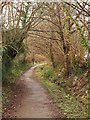
2

Lime Kiln Lane
Footpath WS 10/13 veers off to the left into Round Wood on Milton Hill. Lime Kiln Lane, carrying the West Mendip Way, continues along the edge of the wood.
Image: © Derek Harper
Taken: 22 May 2010
0.19 miles
3
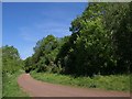
Lime Kiln Lane
Looking in the other direction along the lane shown in Image, carrying footpath WS 10/13E and West Mendip Way, with Round Wood climbing Milton Hill on the right.
Image: © Derek Harper
Taken: 22 May 2010
0.19 miles
4
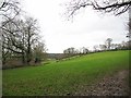
View from Lime Kiln Lane
Looking west across fields from Lime Kiln Lane.
Image: © Sharon Loxton
Taken: 20 Jan 2008
0.20 miles
5
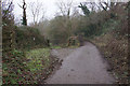
Field entrance off Lime Kiln Lane
The land runs around Milton Hill which rises to the right.
Image: © Bill Boaden
Taken: 30 Dec 2016
0.22 miles
6
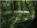
Ramsons, Round Wood
A carpet of the wild garlic Allium ursinum in the wood on Milton Hill, seen from footpath WS 10/13.
Image: © Derek Harper
Taken: 22 May 2010
0.22 miles
7
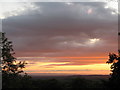
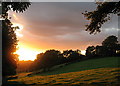
Sunset from Milton Hill
The picture was taken from beside Underwood quarry. The hills in the right background are the Quantocks.
Image: © Sharon Loxton
Taken: 29 Aug 2007
0.22 miles
8
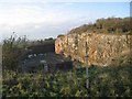
Underwood Quarry
This defunct quarry, overlooking Wells is now used by Thales for their research/testing. Thales, previously Racal previously Thorn, is a major employer in Wells.
Image: © Graham Richards
Taken: 23 Dec 2005
0.23 miles
9
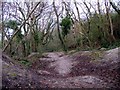
Uneven wooded ground near Lime Kiln Lane.
This patch of uneven ground is adjacent to the Lime Kilns in Lime Kiln Lane, and just south of the disused split rock quarry. It serves as an 'adventure playground' for children who delight in running (and slipping!) or cycling up and down the mounds.
Image: © Sharon Loxton
Taken: 20 Jan 2008
0.23 miles
10
Goodymoor Lane, Wells
With trees alongside and a small watercourse (heading for the River Axe) on the right, footpath WS 17/37 follows the line of an old lane through the modern Goodymoor estate on the northwest side of Wells. On the left are the rears of properties on Goodymoor Avenue.
Image: © Derek Harper
Taken: 22 Feb 2010
0.23 miles