IMAGES TAKEN NEAR TO
Bodden, SHEPTON MALLET, BA4 4PT
Introduction
This page details the photographs taken nearby to BA4 4PT by members of the Geograph project.
The Geograph project started in 2005 with the aim of publishing, organising and preserving representative images for every square kilometre of Great Britain, Ireland and the Isle of Man.

There are currently over 7.5m images from over14,400 individuals and you can help contribute to the project by visiting https://www.geograph.org.uk
Image Map
Images are licensed for reuse under creativecommons.org/licenses/by-sa/2.0
Notes
- Clicking on the map will re-center to the selected point.
- The higher the marker number, the further away the image location is from the centre of the postcode.
Image Listing (10 Images Found)
Images are licensed for reuse under creativecommons.org/licenses/by-sa/2.0
Image
Details
Distance
1
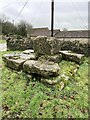
Old Wayside Cross in Bodden
Bodden Cross, the base of an old wayside cross. Set on the south side of a road junction opposite Higher Bodden Farm in Bodden. Doulting parish. Grade II Listed https://historicengland.org.uk/listing/the-list/list-entry/1345190 and a Scheduled Monument https://historicengland.org.uk/listing/the-list/list-entry/1015798.
Milestone Society National ID: SOME_DOU01
Image: © C Evans
Taken: 1 Feb 2024
0.03 miles
2
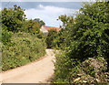
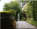
2011 : Bodden Lane, approaching Bodden
Image: © Maurice Pullin
Taken: 11 Jun 2011
0.05 miles
3
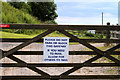
2011 : Friendly sign on a gate, top of Bodden Lane
Image: © Maurice Pullin
Taken: 11 Jun 2011
0.05 miles
4
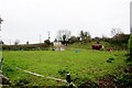
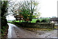
Horse Paddock on Bodden Lane
A small paddock on the edge of this tiny hamlet with a pair of windswept ponies.
Image: © Nigel Mykura
Taken: 5 Nov 2022
0.06 miles
5
2011 : Farm on Bodden Lane
To the north of Ingsdons Hill, with some fine views west toward Glastonbury.
Bits of Shepton Mallet are just visible.
Image: © Maurice Pullin
Taken: 11 Jun 2011
0.09 miles
6
2011 : Bodden Lane leaving Bodden
Heading downhill to Charlton and Shepton Mallet.
Image: © Maurice Pullin
Taken: 11 Jun 2011
0.09 miles
7
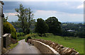
Bodden Lane
Bodden Lane runs south from the small hamlet of Boddeen downhill to the town of Shepton Mallet
Image: © Nigel Mykura
Taken: 5 Nov 2022
0.11 miles
8
2011 : Bodden Lane, west of Bodden
Down the hill to Charlton and Shepton Mallet, bits of which can be seen through the trees.
In the distance to the right Glastonbury Tor stands, Image looking like an old fashioned sugar loaf with a candle on top.
Image: © Maurice Pullin
Taken: 11 Jun 2011
0.17 miles
9
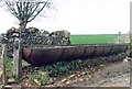
Unusual water trough on the West Mendip Way
Image: © Patrick Mackie
Taken: 18 Feb 2004
0.21 miles
10
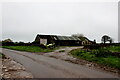
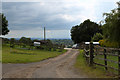
Farm Buildings at Higher Farm
Higher Farm is the most northerly of the farms located at the hamlet of Bodden just north east of Shepton Mallet.
Image: © Nigel Mykura
Taken: 5 Nov 2022
0.23 miles