IMAGES TAKEN NEAR TO
The Mead, RADSTOCK, BA3 5JD
Introduction
This page details the photographs taken nearby to The Mead, BA3 5JD by members of the Geograph project.
The Geograph project started in 2005 with the aim of publishing, organising and preserving representative images for every square kilometre of Great Britain, Ireland and the Isle of Man.

There are currently over 7.5m images from over14,400 individuals and you can help contribute to the project by visiting https://www.geograph.org.uk
Image Map
Images are licensed for reuse under creativecommons.org/licenses/by-sa/2.0
Notes
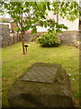
- Clicking on the map will re-center to the selected point.
- The higher the marker number, the further away the image location is from the centre of the postcode.
Image Listing (23 Images Found)
Images are licensed for reuse under creativecommons.org/licenses/by-sa/2.0
Image
Details
Distance
1

Stoke St. Michael: paving on the Millennium Green
Colourful brickwork in the path across the Image; these particular ones at least were clearly designed and crafted by the village primary school.
Image: © Chris Downer
Taken: 23 May 2009
0.03 miles
2
Stoke St. Michael: draughtsboard
This draughtsboard is sculpted into a large stone on the Image
Image: © Chris Downer
Taken: 23 May 2009
0.04 miles
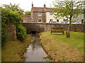
3
Stoke St. Michael: Millennium Green
This little enclave, by the main crossroads, was set out as a small village green in the year 2000.
Image: © Chris Downer
Taken: 23 May 2009
0.05 miles
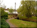
4
Stoke St. Michael: stream through the Green
A small stream flowing through the Image
Image: © Chris Downer
Taken: 23 May 2009
0.05 miles
5

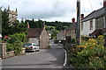
2009 : The Square, Stoke St. Michael
Something about this reminded me of William Shakespeare, only he wrote about the schoolboy making his way to school, this was late afternoon. A delightful moment, I was lucky to catch it.
St. Michael's Church is at the other end of The Square. (square?)
Image: © Maurice Pullin
Taken: 1 May 2009
0.05 miles
6

Direction Sign - Signpost on Stoke Hill, Stoke St Michael
Pyramid finial - 4 arms; Somerset SCC pyramid by the UC road, in parish of Stoke St Michael (Mendip District), on the southwest side of the junction of Mendip Road, Church Street and Stoke Hill.
surveyed
Milestone Society National ID: SO_ST6646
Image: © Milestone Society
Taken: Unknown
0.07 miles
7
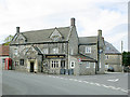
2009 : The Knatchbull Arms, Stoke St. Michael
The question sprang to mind "what is a Knatchbull?" It seems I was not the only one, it was answered in: http://www.sunriseag.net/adoptapub/more/0042Knatchbull.htm
"Well, courtesy of a transatlantic telephone call, we solved it: It is a family name. The Knatchbulls are of course a well-known English blue-blood family on the Mountbatten side, and have a substantial manor nearby. Norton Knatchbull, Baron Romsey is actually 523rd in line for the throne, though I doubt if he has contingency plans just in case he is called upon. The Knatchbulls are in politics and education and have eight other family members on the long royal list."
Along with other interesting information.
Image: © Maurice Pullin
Taken: 1 May 2009
0.08 miles
8
Stoke St Michael: Tower Hill
With the tower of St Michael’s, left. Looking towards the centre of the village
Image: © Martin Bodman
Taken: 8 Aug 2008
0.08 miles
9

Chest tombs, St Michael's Church
The chests date from the 18th and 19th centuries and are of Doulting stone. They are to be found near the church porch.
Image: © Maigheach-gheal
Taken: 31 Aug 2011
0.08 miles
10
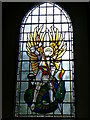
Stained glass window, St Michael's Church
The window shows St Michael slaying the dragon as an allegory to good and evil.
Image: © Maigheach-gheal
Taken: 31 Aug 2011
0.08 miles