
IMAGES TAKEN NEAR TO
Edford Hill, RADSTOCK, BA3 5GY
Introduction
This page details the photographs taken nearby to Edford Hill, BA3 5GY by members of the Geograph project.
The Geograph project started in 2005 with the aim of publishing, organising and preserving representative images for every square kilometre of Great Britain, Ireland and the Isle of Man.

There are currently over 7.5m images from over14,400 individuals and you can help contribute to the project by visiting https://www.geograph.org.uk
Image Map
Images are licensed for reuse under creativecommons.org/licenses/by-sa/2.0
Notes
- Clicking on the map will re-center to the selected point.
- The higher the marker number, the further away the image location is from the centre of the postcode.
Image Listing (12 Images Found)
Images are licensed for reuse under creativecommons.org/licenses/by-sa/2.0
Image
Details
Distance
1

Holcombe: Duke of Cumberland, at Edford Green
A notice by the entrance indicates the pub will re-open on Saturday 9 August [2008]. Presumably the inn commemorates the victor of the Battle of Culloden [1746], also known as ‘Butcher Cumberland’. The duke (1721-1765) was a younger son of King George II
Image: © Martin Bodman
Taken: 8 Aug 2008
0.00 miles
2

Edford Green
Looking down Edford Hill as it drops into the Mells Stream valley.
Image: © Derek Harper
Taken: 1 Apr 2025
0.01 miles

4

2009 : North at the end of Marsh Lane
With a view over pasture to Edford and Holcombe.
Image: © Maurice Pullin
Taken: 1 May 2009
0.03 miles
5

Houses, Edford
At the southern edge of the hamlet.
Image: © Derek Harper
Taken: 1 Apr 2025
0.08 miles
6

Coleford: site of Dorset & Somerset Canal
The canal was begun in the late 18th century but never completed and only sections of the 11-mile long arm from Frome to Nettlebridge, intended to tap the collieries in the valley, were constructed. Work had been abandoned by 1803. The main canal would have linked Bradford-on-Avon, on the Kennet & Avon canal with Sturminster Newton, on the river Stour, in Dorset
Image: © Martin Bodman
Taken: 8 Aug 2008
0.08 miles
7

Edford Hill
Looking the other way from Image], up the hill towards Edford.
Image: © Derek Harper
Taken: 1 Apr 2025
0.09 miles
8
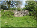
Former canal bridge near Edford
Infilled arch of a bridge over the course of the abandoned Dorset and Somerset Canal.
Image: © David Tyers
Taken: 2 May 2011
0.09 miles
9

2009 : At the end of Marsh Lane
Looking north to Holcombe and Edford Hill.
The small business to the left seems to be holding its own in difficult times.
Marsh Lane is the road to the right.
Image: © Maurice Pullin
Taken: 1 May 2009
0.16 miles
10

Old Direction Sign - Signpost south of Edford, Holcombe Parish
Pyramid finial - 4 arms; Somerset SCC pyramid by the UC road, in parish of Holcombe (Mendip District), Edford Hill junction with Marsh Lane, South of Edford.
Surveyed
Milestone Society National ID: SO_ST6648A
Image: © Milestone Society
Taken: Unknown
0.22 miles