IMAGES TAKEN NEAR TO
Mendip Road, RADSTOCK, BA3 5GA
Introduction
This page details the photographs taken nearby to Mendip Road, BA3 5GA by members of the Geograph project.
The Geograph project started in 2005 with the aim of publishing, organising and preserving representative images for every square kilometre of Great Britain, Ireland and the Isle of Man.

There are currently over 7.5m images from over14,400 individuals and you can help contribute to the project by visiting https://www.geograph.org.uk
Image Map (Loading...)


Getting Data...Please wait
Leaflet Map data © OpenStreetMap
Images are licensed for reuse under creativecommons.org/licenses/by-sa/2.0
Notes
- Clicking on the map will re-center to the selected point.
- The higher the marker number, the further away the image location is from the centre of the postcode.
Image Listing (24 Images Found)
Images are licensed for reuse under creativecommons.org/licenses/by-sa/2.0
Image
Details
Distance

2

Direction Sign - Signpost on Stoke Hill, Stoke St Michael
Pyramid finial - 4 arms; Somerset SCC pyramid by the UC road, in parish of Stoke St Michael (Mendip District), on the southwest side of the junction of Mendip Road, Church Street and Stoke Hill.
surveyed
Milestone Society National ID: SO_ST6646
Image: © Milestone Society
Taken: Unknown
0.13 miles
3
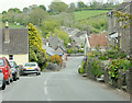
2009 : Stoke Hill, Stoke St. Michael
Looking down Stoke Hill to The Square.
An interesting village, there are limestone quarries all round so it should be a major industry.
Image: © Maurice Pullin
Taken: 1 May 2009
0.15 miles
4
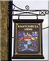
Sign for the Knatchbull Arms
For information on this sign visit http://www.sunriseag.net/adoptapub/more/0042Knatchbull.htm
Image: © Maigheach-gheal
Taken: 31 Aug 2011
0.15 miles
5
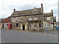
The Knatchbull Arms, Stoke St Michael
The building dates from the late 17th century and it was originally a house. For a view of the sign Image
Image: © Maigheach-gheal
Taken: 31 Aug 2011
0.15 miles
6
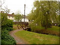
Stoke St. Michael: Millennium Green
This little enclave, by the main crossroads, was set out as a small village green in the year 2000.
Image: © Chris Downer
Taken: 23 May 2009
0.15 miles
7
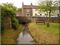
Stoke St. Michael: stream through the Green
A small stream flowing through the Image
Image: © Chris Downer
Taken: 23 May 2009
0.15 miles
8
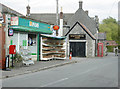
2009 : Post Office and village store, Stoke St. Michael
With a tempting array of goodies. Unfortunately my wallet was in the car at the top of the hill.
This is at the foot of Stoke Hill which is behind the camera.
'The village is considered a healthy spot, one-fourth of the persons dying within the last half century having exceeded 70 years. W. F. Knatchbull, Esq., M.P., is lord of the manor."
From The National Gazetteer of Great Britain and Ireland (1868)'
The above was copied from: http://www.stokestmichael.org.uk/
Very interesting village website if you take the trouble to delve into it.
Image: © Maurice Pullin
Taken: 1 May 2009
0.15 miles
9

Stoke St. Michael: paving on the Millennium Green
Colourful brickwork in the path across the Image; these particular ones at least were clearly designed and crafted by the village primary school.
Image: © Chris Downer
Taken: 23 May 2009
0.15 miles
10

2009 : The Square, Stoke St. Michael
Something about this reminded me of William Shakespeare, only he wrote about the schoolboy making his way to school, this was late afternoon. A delightful moment, I was lucky to catch it.
St. Michael's Church is at the other end of The Square. (square?)
Image: © Maurice Pullin
Taken: 1 May 2009
0.16 miles