IMAGES TAKEN NEAR TO
Common Lane, RADSTOCK, BA3 5FR
Introduction
This page details the photographs taken nearby to Common Lane, BA3 5FR by members of the Geograph project.
The Geograph project started in 2005 with the aim of publishing, organising and preserving representative images for every square kilometre of Great Britain, Ireland and the Isle of Man.

There are currently over 7.5m images from over14,400 individuals and you can help contribute to the project by visiting https://www.geograph.org.uk
Image Map
Images are licensed for reuse under creativecommons.org/licenses/by-sa/2.0
Notes
- Clicking on the map will re-center to the selected point.
- The higher the marker number, the further away the image location is from the centre of the postcode.
Image Listing (17 Images Found)
Images are licensed for reuse under creativecommons.org/licenses/by-sa/2.0
Image
Details
Distance
1

Memorial window to Marjorie Jackson
Stained glass in the new St Andrew's parish church.
Image: © Tiger
Taken: 14 Jul 1996
0.01 miles

3

Direction Sign - Signpost on a crossroads on Holcombe Hill
Pyramid finial - 3 arms; Somerset SCC pyramid by the UC road, in parish of Holcombe (Mendip District), crossroads of Holcombe Hill, Kingsway & Common Lane.
surveyed
Milestone Society National ID: SO_ST6749A
Image: © Milestone Society
Taken: Unknown
0.04 miles
4
2009 : Holcombe Hill, Holcombe
Looking south from the Brewery Lane crossroads toward Edford and Stoke St.Michael. The Mendip Hills are in the distance.
Image: © Maurice Pullin
Taken: 22 Mar 2009
0.05 miles
5
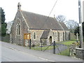
Holcombe St Andrew
The new church, desperately dull when compared with the old church Image
Image: © ChurchCrawler
Taken: 16 Mar 2006
0.06 miles
6

Holcombe Old Vicarage
Former vicarage on Holcombe Hill, near the new church of St Andrew.
Image: © Tiger
Taken: 14 Jul 1996
0.06 miles
7

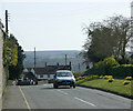
2009 : Holcombe crossroads
Seen from Stratton Road, Brewery Lane is straight ahead, Charlton Road to the left and Holcombe Hill to the right.
The signpost to Radstock and Bath was fitted to the edge of the frame at no extra charge.
Image: © Maurice Pullin
Taken: 22 Mar 2009
0.09 miles
8

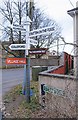
Too much information!
Somerset County Council's signpost at Holcombe village crossroads, with its pyramidal finial, offers a bewildering choice of destinations!
Update: for a view 17 years later, with the destinations edited and mileages removed, but new local attractions added, see Image
Image: © Tiger
Taken: 14 Jul 1996
0.10 miles
9
Old Direction Sign - Signpost by Stratton Hill, Holcombe Parish
Pyramid finial - 4 arms; Somerset SCC pyramid by the UC road, in parish of Holcombe (Mendip District), by crossroads of Stratton Road, Charlton Road, Brewery Lane and Holcombe Hill.
Surveyed
Milestone Society National ID: SO_ST6749
For a 1996 photo see: Image
Image: © Milestone Society
Taken: Unknown
0.11 miles