IMAGES TAKEN NEAR TO
Bath Road, RADSTOCK, BA3 5AE
Introduction
This page details the photographs taken nearby to Bath Road, BA3 5AE by members of the Geograph project.
The Geograph project started in 2005 with the aim of publishing, organising and preserving representative images for every square kilometre of Great Britain, Ireland and the Isle of Man.

There are currently over 7.5m images from over14,400 individuals and you can help contribute to the project by visiting https://www.geograph.org.uk
Image Map
Images are licensed for reuse under creativecommons.org/licenses/by-sa/2.0
Notes
- Clicking on the map will re-center to the selected point.
- The higher the marker number, the further away the image location is from the centre of the postcode.
Image Listing (8 Images Found)
Images are licensed for reuse under creativecommons.org/licenses/by-sa/2.0
Image
Details
Distance
1
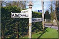
Direction Sign - Signpost on the A367 Bath Road
Pyramid finial - 3 arms; Somerset SCC pyramid by the A367, in parish of Ashwick (Mendip District), on the west side of the T junction of the A367 Bath Road and Withy Lane, south of Neighbourne.
surveyed
Milestone Society National ID: SO_ST6447
Image: © J Dowding
Taken: 15 Feb 2013
0.07 miles

3

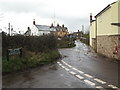
2011 : A367 approaching Nettlebridge
Then on to Stratton-on-the-Fosse and Radstock.
Image: © Maurice Pullin
Taken: 9 Jan 2011
0.12 miles
4

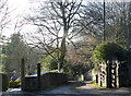
To Home Wood
The path crosses the field and finds the woodlands. Beyond is Harridge Wood, a nature reserve owned and operated by Somerset Wildlife Trust.
Image: © Neil Owen
Taken: 20 Aug 2020
0.12 miles
6
2011 : Footpath into the valley at Ashwick
Leaving the A367 at the top of the hill between Nettlebridge and Oakhill, the footpath follows a private drive into the valley and shortly joins the route of the Fosse Way as it heads south to Shepton Mallet.
Image: © Maurice Pullin
Taken: 9 Jan 2011
0.23 miles
7

2011 : A367 passing Ashwick
Heading south west half a mile from Oakhill. Near the top of the hill climbing out of Nettlebridge.
Harridge Farm peeps over the hill.
Image: © Maurice Pullin
Taken: 9 Jan 2011
0.24 miles
8
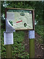
The red line marks the problem
Harridge Woods are a nature reserve that has a number of paths through it. However, the application of some red tape on the map shows that part of the woods are out of bounds. The area has been hit badly by Ash Dieback (Hymenoscyphus fraxineus fungus) and some trees are unstable now.
Image: © Neil Owen
Taken: 20 Aug 2020
0.25 miles