IMAGES TAKEN NEAR TO
Ford Road, RADSTOCK, BA3 4SR
Introduction
This page details the photographs taken nearby to Ford Road, BA3 4SR by members of the Geograph project.
The Geograph project started in 2005 with the aim of publishing, organising and preserving representative images for every square kilometre of Great Britain, Ireland and the Isle of Man.

There are currently over 7.5m images from over14,400 individuals and you can help contribute to the project by visiting https://www.geograph.org.uk
Image Map
Images are licensed for reuse under creativecommons.org/licenses/by-sa/2.0
Notes
- Clicking on the map will re-center to the selected point.
- The higher the marker number, the further away the image location is from the centre of the postcode.
Image Listing (8 Images Found)
Images are licensed for reuse under creativecommons.org/licenses/by-sa/2.0
Image
Details
Distance
1
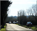
2012 : B3114 leaving Litton
Heading for Ford and Chewton Mendip.
OS Map 141 marks a disused shaft in the field to the right, coal and lead were mined in this area.
Image: © Maurice Pullin
Taken: 26 Feb 2012
0.04 miles
2

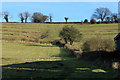
2012 : Field in the Chew Valley south of Litton
The B3114 is to the right on the other side of the hedge, the River Chew is at the valley bottom to the left.
Litton was once a mining village, now solar panels are a source of energy.
Image: © Maurice Pullin
Taken: 26 Feb 2012
0.08 miles
3
2012 : East from the B3114 near Litton
Seen from the bottom of a steep sided valley which extends north west from Chewton Mendip carrying the River Chew through Litton, Sherborne and South Widcombe to the Chew Valley Lake.
This area is part of the North Somerset coalfield, now disused, there are many old shafts along this valley, lead was also mined in former times.
Image: © Maurice Pullin
Taken: 26 Feb 2012
0.10 miles
4
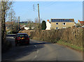
2012 : B3114 approaching Litton from the south
"Litton was listed in the Domesday Book of 1086 as Litune, meaning 'The small enclosure' from the Old English lyt and tun. It was the property of Gisa, Bishop of Wells.
The shape of some of the existing fields with cross-slope and down-slope field banks and cultivated ridges forming an interleaving irregular mosaic suggest they are of medieval origin." Copied from http://en.wikipedia.org/wiki/Litton,_Somerset
Image: © Maurice Pullin
Taken: 26 Feb 2012
0.12 miles
5

Short hop over the Chew
A footpath directs the traveller down a short flight of steps to the little bridge. Along the banks are a number of what appear to be the back gardens of several properties. Perhaps because of this the bridge has a metal frame to obstruct wheeled vehicles - see Image
Image: © Neil Owen
Taken: 3 Apr 2013
0.19 miles
6

That'll stop them!
A curious frame of tubular metal both helps and hinders progress over the little wooden bridge over the Chew.
Image: © Neil Owen
Taken: 3 Apr 2013
0.19 miles