IMAGES TAKEN NEAR TO
Warbler Close, RADSTOCK, BA3 4GZ
Introduction
This page details the photographs taken nearby to Warbler Close, BA3 4GZ by members of the Geograph project.
The Geograph project started in 2005 with the aim of publishing, organising and preserving representative images for every square kilometre of Great Britain, Ireland and the Isle of Man.

There are currently over 7.5m images from over14,400 individuals and you can help contribute to the project by visiting https://www.geograph.org.uk
Image Map (Loading...)


Getting Data...Please wait
Leaflet Map data © OpenStreetMap
Images are licensed for reuse under creativecommons.org/licenses/by-sa/2.0
Notes
- Clicking on the map will re-center to the selected point.
- The higher the marker number, the further away the image location is from the centre of the postcode.
Image Listing (5 Images Found)
Images are licensed for reuse under creativecommons.org/licenses/by-sa/2.0
Image
Details
Distance
1
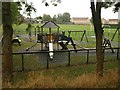
Playground, Fosse Way
At the southern corner of the recreation ground seen in the background.
Image: © Derek Harper
Taken: 7 Oct 2009
0.21 miles
2
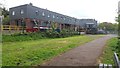
Industrial Buildings on site of Colliery
These buildings stand on or almost on the site of Norton Hill Colliery (No. 1). The tarmac path is the site of sidings serving the colliery.
Image: © Paul Collins
Taken: 1 May 2017
0.22 miles
3

Path Through Former Railway
In the 19th century a path passed under the railway at this point, joining the town with Norton Hill Farm. Later the alignment became Pit Road and was the main access to Norton Hill Colliery (No. 1). Today the railway and colliery have gone but a spoil heap remains, merging with the railway embankment, just visible on the left.
Image: © Paul Collins
Taken: 1 May 2017
0.22 miles

