IMAGES TAKEN NEAR TO
Wells Road, RADSTOCK, BA3 3RQ
Introduction
This page details the photographs taken nearby to Wells Road, BA3 3RQ by members of the Geograph project.
The Geograph project started in 2005 with the aim of publishing, organising and preserving representative images for every square kilometre of Great Britain, Ireland and the Isle of Man.

There are currently over 7.5m images from over14,400 individuals and you can help contribute to the project by visiting https://www.geograph.org.uk
Image Map
Images are licensed for reuse under creativecommons.org/licenses/by-sa/2.0
Notes
- Clicking on the map will re-center to the selected point.
- The higher the marker number, the further away the image location is from the centre of the postcode.
Image Listing (85 Images Found)
Images are licensed for reuse under creativecommons.org/licenses/by-sa/2.0
Image
Details
Distance
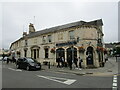
1
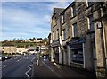
The Street, Radstock
The main A367 road through Radstock, with a bank on the immediate right of the camera.
Image: © Derek Harper
Taken: 26 Nov 2009
0.03 miles
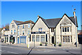
2
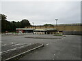
Abandoned Co-op supermarket, Radstock
The largest building in the centre of Radstock, now abandoned and replaced by a smaller store nearby.
Image: © Jonathan Thacker
Taken: 23 Sep 2021
0.03 miles
3
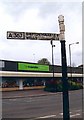
Direction Sign - Signpost by the A367 in Radstock
Lost finial - 1 arm; Somerset SCC pyramid by the A367, in parish of Norton Radstock (Bath and North East Somerset District), Wells Road, junction with The Street. The signpost was on a grass triangle with a tree, all of which have been swept away leaving a wide open junction, sometime after 2012.
Surveyed
Milestone Society National ID: SO_ST6854
Image: © Milestone Society
Taken: Unknown
0.03 miles
4
Barber on the corner of Fortescue Road, Radstock
Image: © Jonathan Thacker
Taken: 23 Sep 2021
0.03 miles
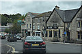
5
Restaurant in Radstock
Castello restaurant in Radstock.
Image: © Wayland Smith
Taken: 2 Apr 2021
0.03 miles
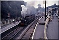
7
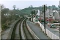
Radstock North station after closure
A sad looking Radstock North station taken around the early 1980s from the footbridge towards the level crossing gates and signal box
Image: © b Lewis
Taken: Unknown
0.04 miles
8
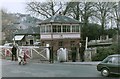
Radstock North Signal Box
The signal box in Radstock after the closure of the line but before the signal box was removed to Didcot.
The signalbox was removed on 23rd November 1975 by the Bristol Group of the Great Western Society and transported to Didcot Railway Centre. Ref: http://www.gwsbristol.org/hradstock_restoration.html
Image: © b Lewis
Taken: Unknown
0.04 miles
9
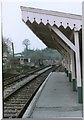
Radstock North platform
The platform at Radstock North station after closure viewed from the East. The level crossing gates were in the centre of the town adjacent to the signal box, now at Didcot. Date is approximate, around early 1980s.
Image: © b Lewis
Taken: Unknown
0.04 miles