IMAGES TAKEN NEAR TO
Manor Road, RADSTOCK, BA3 3LX
Introduction
This page details the photographs taken nearby to Manor Road, BA3 3LX by members of the Geograph project.
The Geograph project started in 2005 with the aim of publishing, organising and preserving representative images for every square kilometre of Great Britain, Ireland and the Isle of Man.

There are currently over 7.5m images from over14,400 individuals and you can help contribute to the project by visiting https://www.geograph.org.uk
Image Map
Images are licensed for reuse under creativecommons.org/licenses/by-sa/2.0
Notes
- Clicking on the map will re-center to the selected point.
- The higher the marker number, the further away the image location is from the centre of the postcode.
Image Listing (7 Images Found)
Images are licensed for reuse under creativecommons.org/licenses/by-sa/2.0
Image
Details
Distance
1
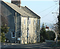
2008 : Cottage at the top, Writhlington
This cottage stands at the top of the very steep hill that plunges down to Lower Writhlington.
Image: © Maurice Pullin
Taken: 16 Feb 2008
0.08 miles
2
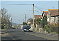
2008 : Writhlington
Looking along the A362 toward Radstock. Writhlington was a mining village, coal was taken by tramway to Radstock then on the Radstock Tramway to Midford and onward by canal. Traces of mining activity can still be found around the village. http://www.radstock4u.com/villagepages/writhlington/
Image: © Maurice Pullin
Taken: 16 Feb 2008
0.11 miles
3
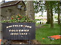
Collieries flowerpot
Writhlington, in common with many villages in the North Somerset coalfields, has little left of its industrial heritage. Also in common, an old piece of ironmongery is placed to remind people of the legacy. Playing fields are in the background.
Image: © Neil Owen
Taken: 11 Jun 2014
0.12 miles
4
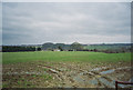
Fields looking towards Writhlington
Image: © Dominic Dawn Harry and Jacob Paterson
Taken: 19 Feb 2006
0.12 miles
5
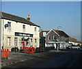
2008 : Fir Tree Inn, Writhlington
With a very good convenience store on the other side of the A362. Be careful as you cross this road.
Image: © Maurice Pullin
Taken: 16 Feb 2008
0.13 miles
6
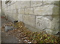
Fir Tree benchmark
A cutmark, as listed in the Benchmark Database: http://www.bench-marks.org.uk/bm57966 , on the former Fir Tree Inn at Writhlington. See Image] for a wider view of this empty public house.
Image: © Neil Owen
Taken: 11 Jun 2014
0.13 miles
7
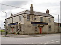
Fallen timber
The former Fir Tree Inn at Writhlington, now closed and looking forlorn. It dates back to 1832 and is believed to be named after a local tree (a 'holy elm') where seats were arranged around its base and the locals used to meet and socialise. The inn was a popular and active place for many groups and organisations; however, it also had its darker side when a poor coal haulier was murdered by three others; one of the accused was acquitted, another transported but the other hanged.
The present building is Grade II listed, but owners Pegasus Planning Group want to convert it into residential use. However, the inn has now lain empty for a few years now.
See Image] for a benchmark on the far right corner.
Image: © Neil Owen
Taken: 11 Jun 2014
0.13 miles