IMAGES TAKEN NEAR TO
Mendip Way, RADSTOCK, BA3 3HH
Introduction
This page details the photographs taken nearby to Mendip Way, BA3 3HH by members of the Geograph project.
The Geograph project started in 2005 with the aim of publishing, organising and preserving representative images for every square kilometre of Great Britain, Ireland and the Isle of Man.

There are currently over 7.5m images from over14,400 individuals and you can help contribute to the project by visiting https://www.geograph.org.uk
Image Map
Images are licensed for reuse under creativecommons.org/licenses/by-sa/2.0
Notes
- Clicking on the map will re-center to the selected point.
- The higher the marker number, the further away the image location is from the centre of the postcode.
Image Listing (41 Images Found)
Images are licensed for reuse under creativecommons.org/licenses/by-sa/2.0
Image
Details
Distance
1
2009 : Bath Old Road, Radstock
As the name suggests this was the main road between Radstock and Bath until the improvements to the A367.
The hill on the other side of the valley rises to Haydon.
Image: © Maurice Pullin
Taken: 16 Nov 2009
0.03 miles
2

2009 : Bath Old Road out of Radstock
The former coach road to Bath, that hill would have been hard for the horses.
New Bath Road is the A367.
Image: © Maurice Pullin
Taken: 16 Nov 2009
0.13 miles

4
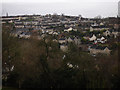
2009 : Coombend from the A367
Looking toward Clandown.
The red sign advertises the Coombend Fish Bar. They were just starting their lunchtime fry up.
Image: © Maurice Pullin
Taken: 16 Nov 2009
0.16 miles
5
Frome Road, Radstock
View from Bath Old Road to Frome Road
Image: © Thomas Pinkney
Taken: 13 Dec 2006
0.16 miles
6
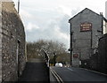
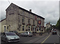
2009 : Coombend and the Radstock Hotel
The map for this square is inaccurate, Coombend joins the A367 at a much sharper angle.
The Radstock Hotel looks as if it should have a long and interesting history but can find none of it on the web.
Image: © Maurice Pullin
Taken: 16 Nov 2009
0.17 miles
8
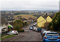
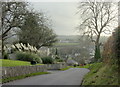
Woodborough Road, Tyning
The road leads down through a housing estate towards Radstock. The settlement on the hill across the valley is Haydon, in Image
Image: © Derek Harper
Taken: 25 Feb 2009
0.19 miles
9
New Church of England School, Tyning, Radstock
Image: © Dominic Dawn Harry and Jacob Paterson
Taken: 19 Feb 2006
0.19 miles
10
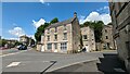
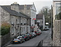
2 Market Place, Radstock
https://historicengland.org.uk/listing/the-list/list-entry/1320559?section=official-list-entry
Image: © Sandy Gerrard
Taken: 6 Jun 2024
0.19 miles