IMAGES TAKEN NEAR TO
Tyning Hill, RADSTOCK, BA3 3ET
Introduction
This page details the photographs taken nearby to Tyning Hill, BA3 3ET by members of the Geograph project.
The Geograph project started in 2005 with the aim of publishing, organising and preserving representative images for every square kilometre of Great Britain, Ireland and the Isle of Man.

There are currently over 7.5m images from over14,400 individuals and you can help contribute to the project by visiting https://www.geograph.org.uk
Image Map
Images are licensed for reuse under creativecommons.org/licenses/by-sa/2.0
Notes
- Clicking on the map will re-center to the selected point.
- The higher the marker number, the further away the image location is from the centre of the postcode.
Image Listing (7 Images Found)
Images are licensed for reuse under creativecommons.org/licenses/by-sa/2.0
Image
Details
Distance
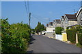
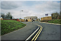
1
Tyning Hill, Radstock
Housing in a northern suburb of Rdastock. The road leads to Image As the sign indicates, this is the point where cycleway NCN24, which follows the line of the Somerset & Dorset Joint Railway along the Wellow Brook valley, leaves the road.
Image: © Derek Harper
Taken: 25 Feb 2009
0.06 miles
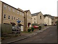
3
New Church of England School, Tyning, Radstock
Image: © Dominic Dawn Harry and Jacob Paterson
Taken: 19 Feb 2006
0.21 miles
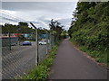
4
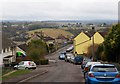
Woodborough Road, Tyning
The road leads down through a housing estate towards Radstock. The settlement on the hill across the valley is Haydon, in Image
Image: © Derek Harper
Taken: 25 Feb 2009
0.21 miles
5
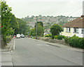
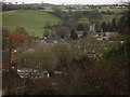
2009 : A362 Frome Road, Radstock
On the corner of Mells Lane looking down the hill into Radstock.
Tyning in the distance to the right.
Image: © Maurice Pullin
Taken: 10 Aug 2009
0.23 miles